Some of Provence’s loveliest villages sit surprisingly close together. In one compact corner framed by the Monts de Vaucluse and the Luberon, you find flowing canals, pale limestone hills, medieval streets, dry stone huts, glowing ochre cliffs, a quiet monastery, hilltop castles, vineyards, and olive country.
The real joy is not simply ticking off twelve pretty places. It is watching the scenery and character of Provence change gently from one short stretch of road to the next. 😊
1. L’Isle-sur-la-Sorgue – Begin With Water, Wheels, Antiques and an Unusually Lively Provençal Town
a. Why you should start here
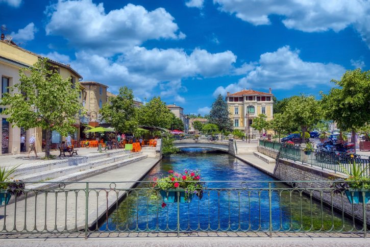
This is an island town, wrapped and split by the branches of the river Sorgue. Instead of dry stone and silence, you get canals, bridges, reflections, and cool, watery air. It is the busiest and most animated stop on the route, and a lively warm-up before the quieter villages ahead.
b. Follow the water and the old wheels
The river once powered mills and factories, and the moss-covered waterwheels (roues à aubes) are the proof. Look for:
- Roughly 15 to 17 historic wheels spread through the waterways.
- A key cluster along Rue Théophile Jean, long called the “street of the wheels”.
- Green cushions of moss on the turning blades, fed by constant cold spray.
- Stone weirs churning the clear water into white foam.
These are working survivors, not decoration. Along the Rue des Roues, 17 of the town’s wheels once lined the Canal de l’Arquet, part of a network that powered a busy wool and silk trade.
c. Step inside the Collégiale Notre-Dame-des-Anges
The town’s main church is one of the finest examples of Southern French Baroque in the region. Inside, watch for:
- 222 carved angels and cherubs across the vaults and paneling.
- A gilded choir and a fine organ tribune from 1648.
- Seventeenth-century altarpieces in the side chapels.
Around it, quiet streets still hold traces of the former Jewish quarter, one of only four protected communities in the old papal Comtat Venaissin.
d. Lose yourself in the antiques
L’Isle-sur-la-Sorgue is often called the third-largest antiques center in Europe, after London and Paris. You will find:
- Over 300 permanent dealers, brocanteurs, and galleries open year-round.
- Distinct hubs like the Village des Antiquaires de la Gare and L’Île aux Brocantes.
- A Provençal market on Thursday and Sunday mornings, mixing melons, cheese, and cherries with linens and pottery along the water.
Just wander and browse. That is the real experience here.
e. A few quieter water details
Along calmer canals, look for the flat-bottomed Nègo Chin boats once used to net trout and crayfish. About two kilometers upstream sits the Partage des Eaux, where the single river splits in two under plane trees and willows.
Next, follow the water to its source. Leaving town simply means heading upstream, where the plain narrows into a cliff-lined canyon.
2. Fontaine-de-Vaucluse – Follow the Sorgue to Its Extraordinary Source Beneath the Cliffs
a. Why it feels so different
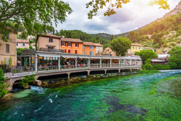
Fontaine-de-Vaucluse sits at the end of a closed valley, ringed by limestone walls over 230 meters high. Here the story is water, rock, and mystery, a world apart from the busy canals you just left.
b. Walk up to the spring
The main experience is the walk along the Chemin de la Fontaine to the Gouffre, the source of the river. Keep in mind:
- It is the most powerful karst spring in France and one of the largest in the world.
- It drains a huge underground network fed by rain and snowmelt.
- After heavy rain, water surges over the lip in a churning flood.
- In dry summer, the level drops into a calm, dark green pool.
A quiet pool does not mean the source has dried up. It simply flows out through lower fissures instead, still active underground.
c. See the paper mill
Beside the river, the Moulin à Papier Vallis Clausa links this stop straight back to the mills of L’Isle-sur-la-Sorgue. Inside you can watch traditional rag paper made the old way:
- A waterwheel turns a shaft fitted with cams.
- Heavy wooden mallets pound cloth scraps into pulp.
- Papermakers lift each sheet on a mesh frame, press it, and hang it to dry.
Papermaking has thrived here since the fifteenth century, helped by the steady, clean water.
d. Visit the church of Notre-Dame-et-Saint-Véran
Set back from the path, this church gives the village a solid medieval layer. It was built over a sixth-century sanctuary, with plain, fortress-like walls. Look for:
- The sarcophagus of Saint Véran, a bishop tied to a local dragon legend.
- An ancient marble altar reusing old Roman stone.
- Carved panels with ninth-century interlace patterns.
e. A quiet literary side
The Italian poet Francesco Petrarch lived in this valley between 1337 and 1353, and the village still remembers him. Worth a look:
- The Musée-Bibliothèque François Pétrarque, where his home once stood.
- Place de la Colonne, marked by a granite column raised for his 500th anniversary.
- The ruined towers of an old episcopal castle above the village.
Next, climb out of the gorge. The green riverbanks give way to dry, open scrub as you rise toward Cabrières-d’Avignon.
3. Cabrières-d’Avignon – Slow Down for Dry-Stone Provence, Cedar Woods and a Difficult History
a. The route’s quiet stop
Cabrières-d’Avignon has no famous cliffs or market, and that is the point. Sitting between the Monts de Vaucluse and the Luberon plain, it is a place of working farms, calm streets, and stone built without mortar. Come here to read the everyday, rural side of Provence.
b. Learn to read the dry-stone work
In this dry land, stone was cleared from fields and stacked into useful shapes. Learn to spot:
- Borie: a corbelled dry-stone hut, once a field shelter.
- Aiguier: a rock-cut basin that caught and stored rainwater.
- Restanque: an unmortared terrace wall holding soil on slopes.
- Mur apier: stone niches built into walls to shelter beehives.
Each was a practical answer to a hard landscape.
c. The history that adds weight
Behind the calm streets lies a hard story. Empty Luberon land here was settled by Waldensians, followers of an early reform movement. In April 1545, royal troops attacked the village:
- Villagers and refugees sheltered behind the château walls.
- After a promised safe passage, troops entered anyway, and between 400 and 500 people were killed.
- The restored Château de Cabrières still stands as a quiet reminder.
d. Walk part of the Mur de la Peste
North of the village runs the Mur de la Peste (Plague Wall), built in 1721 to keep the Great Plague of Marseille out of papal territory. Notice:
- It stretched about 27 kilometers across the hills, roughly two meters tall.
- It had guard shelters and was patrolled by more than a thousand troops.
- About six kilometers have been restored, and you can walk it straight from the village.
It is both public health history and fine local stonework.
e. Find the cedar wood
Just north lies a small cedar wood, planted in 1860 with Atlas cedar seeds from North Africa. This is not the larger, more famous cedar forest near Bonnieux. It gives you deep shade, soft needles, and cool air, a real surprise after the hot garrigue all around.
Next, move toward stone and silence. The farmland gives way to a rocky gorge that leads to a hidden twelfth-century monastery.
4. Abbaye Notre-Dame de Sénanque – Let Silence, Stone and the Valley Become the Attraction
a. More than a lavender photo
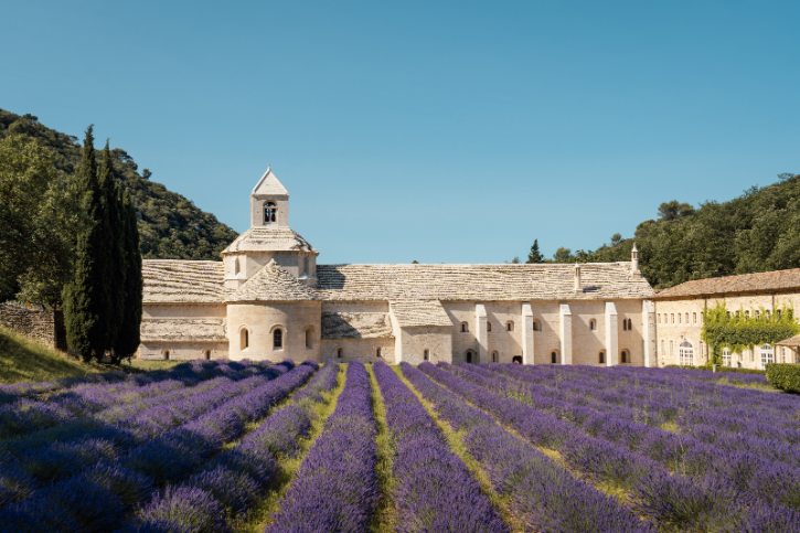
Abbaye Notre-Dame de Sénanque is a living Cistercian monastery, home to a real community of monks who still balance prayer, silence, and work. Tucked into a dry ravine, it was built to withdraw from the world, and you feel that the moment you arrive.
b. Know the history
Sénanque was founded on June 23, 1148, by Cistercian monks. Its plain look is on purpose, following the ideals championed by Saint Bernard of Clairvaux:
- No narrative carvings or decorative creatures.
- Balanced, geometric proportions and clean lines.
- Bare stone, left unpainted, so natural light does the decorating.
Together with Silvacane and Le Thoronet, it forms the Three Cistercian Sisters of Provence.
c. What to notice inside
The rooms make sense once you picture daily monastic life. As you move through, look at each space and its purpose:
- The abbey church: simple and unadorned, tuned for chant, and facing north to south because the canyon is so narrow.
- The chapter house: rib vaults springing from low columns, where monks gathered daily.
- The dormitory: a plain vaulted hall for sleeping.
- The calefactory: the only heated room, where scribes could work in winter.
d. Spend time in the cloister
The cloister is the quiet heart of the place. Its covered walkways linked the main rooms and gave the monks a sheltered space to walk and pray. Look closely at the paired columns, carved only with leaves, pinecones, and geometric shapes, never faces or bible scenes. Sunlight through the arches turns the whole space into a slow study of light and shadow.
e. The lavender, handled honestly
The lavender is a working crop that helps fund the buildings. A few honest points:
- You cannot walk into the rows. The fields are fenced to protect the plants and the quiet.
- Flowering usually runs from mid-June to a peak in early July.
- Outside that window, the fields fade to grey-green.
Enjoy the color, but treat it as the protected farmland it is.
Next, rise to the hillside. The ravine opens to reveal Gordes spread across a rocky slope.
5. Gordes – Give the Famous Village Enough Depth to Justify Its Reputation
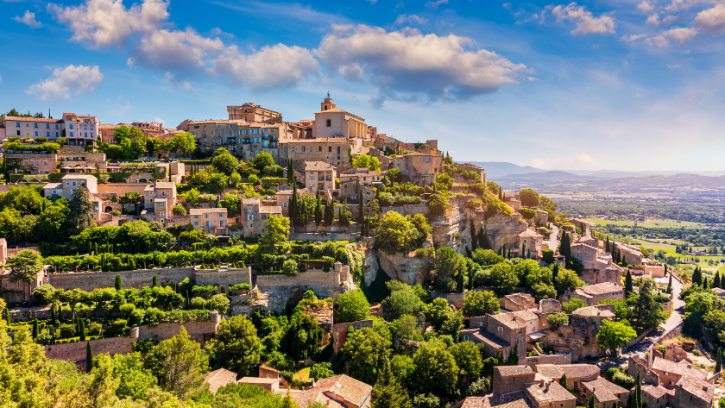
a. Begin with the silhouette
Gordes is one of the best-known hilltop villages in Provence, listed among Les Plus Beaux Villages de France. Pale stone houses stack along steep terraces, with the church and fortress at the top. It earns the fame, but there is far more here than the postcard, so walk the lanes.
b. Start at the classic viewpoint
The best first look is from Rocher Bel-Air, on the southern approach. From here you can see:
- How the village perches at about 340 metres above sea level on its rocky promontory.
- How the outer houses form a continuous defensive wall.
- How the light shifts, pale in the morning, golden in late afternoon.
Read the village from here before you step inside.
c. Explore the historic center
Through the upper gates you reach Place du Château and the Château de Gordes, a fortress that became a home. Founded in 1031 and rebuilt in 1525, it mixes heavy towers and gun loops with a grand spiral staircase and a carved 1541 fireplace. Away from the square, the mood softens along the calades, the old stepped cobblestone lanes, past quiet passages and walled gardens.
d. Go underground at the Caves du Palais Saint-Firmin
Beneath the houses hides a whole other world, carved across seven rock levels. It reveals the working village that fed the pretty one above:
- Rock-cut basins of a subterranean olive oil mill.
- Stone tanks where oil was settled and separated.
- Grain stores and cisterns to survive dry spells or sieges.
e. Small details to look for
- Central drainage gutters chiseled into the calades.
- Galleries in vaulted stone rooms, part of the art history that drew painters like Marc Chagall and Victor Vasarely.
- Square scaffolding holes and corner niches left by medieval builders.
Next, ease off the drama. The route crosses the valley floor toward a village that hides along a low, wooded ridge.
6. Goult – Make the “Hidden Village” the Route’s Lesson in Looking Closely
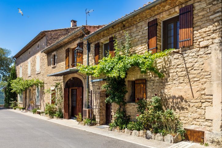
a. Why it deserves a stop
Goult is known locally as the hidden village, and it is the ideal follow-up to Gordes. There are no dramatic cliffs, crowds, or famous silhouette, just well-kept streets and small details that add up, so slow right down here.
b. Climb from the square to the crest
The best plan is a gentle climb through the village:
- Start in the shaded Place de la Libération, with its café and food shops.
- Walk up through streets that shift from pale limestone to warm golden sandstone.
- Pass under vaulted arches to Place du Castelet, where the views open up.
c. Anchor your wander with landmarks
History pokes out of the everyday buildings here:
- Sections of twelfth and fourteenth-century walls and old defensive gates.
- Château de Goult, built by the powerful Agoult family, now private.
- Église Saint-Sébastien, a Romanesque church with a gilded seventeenth-century altarpiece inside.
d. Find the Moulin de Jérusalem
At the top of the village stands the restored Moulin de Jérusalem, one of Goult’s best-loved sights. Worth knowing:
- It is a stone tower windmill, recorded as working by 1750.
- Its name recalls the Agoult lords’ part in the Crusades.
- It was carefully restored by the commune in the late 1990s.
From the terrace beside it, you can look across the valley toward the Luberon, with a covered washhouse and cistern just below.
e. Walk the terraced landscape
A path south of the windmill drops into the Conservatoire des Terrasses de Cultures, a five-hectare site preserving classic terraced farming. Along the paths you will see:
- Restanques, stepped dry-stone walls holding soil on the slope.
- Restored rainwater basins and small stone shelters.
- Olive, almond, and fig trees, plus aromatic herbs.
It shows how families shaped steep ground into farmland.
Next, watch the color change. The pale limestone fades, the soil turns orange, and Roussillon glows on the ridge ahead.
7. Roussillon – Let Geology Color Both the Landscape and the Village
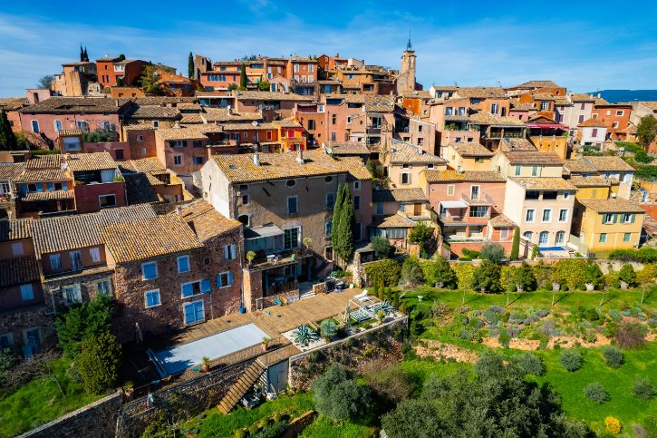
a. Make color the whole idea
Roussillon sits on one of the largest ochre deposits in Europe, and that single fact shaped everything. The houses share the same minerals as the cliffs, coated in lime washes tinted with local ochre. The result is a townscape of yellow, saffron, terracotta, and deep red.
b. Walk the village before the trail
Most people rush to the quarries, but the streets deserve time first. Look for:
- Varied façades, from light yellow to burnt orange, with green, grey, and blue shutters.
- Weathering streaks where rain has washed pigment down the walls.
- Bright climbers like bougainvillea and wisteria against the warm stone.
c. See the upper village
A few landmarks give the walk some shape:
- Le Beffroi, a bell tower built over an old twelfth-century gateway.
- Église Saint-Michel, perched at the highest point, its choir set against the cliff.
- The cliffside belvedere behind the church, with views to Gordes and Mont Ventoux.
d. Take the Sentier des Ocres
At the edge of the village begins the ochre trail, the essential nature experience here. It winds through old quarries into a sculpted landscape. You will meet:
- Fluted spires and towers with names like the Giants’ Causeway and Fairy Chimneys.
- Green pines and gorse standing bright against the red sand.
- Two loops, roughly 30 and 60 minutes, on protected boardwalks.
The colors formed as iron-rich sands were weathered over millions of years, with heat turning some yellows into deep reds.
e. Add the human history
People have used this ochre since Roman times, but the modern industry took off in the 1780s, founded by a local man named Jean-Étienne Astier. To see how it worked, visit Ôkhra, the ochre ecomuseum in an old plant that ran until 1958. It keeps the washing channels, drying sheds, mills, and kilns that turned raw earth into pigment.
Next, trade color for austerity. Climbing the Petit Luberon, the bright tones fade, and pale, weathered Lacoste rises ahead.
8. Lacoste – Use Steep Lanes, Castle Ruins and an Arts Legacy to Create a Darker, More Atmospheric Stop
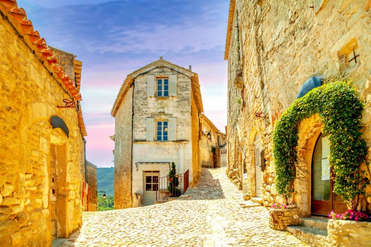
a. Why it feels serious
After the warmth of Roussillon, Lacoste feels steep and brooding. It stands on a spur facing its sister village, Bonnieux, across the valley. There are no open squares here, just a climbing citadel of cobbled lanes, vaulted passages, and plain stone houses topped by a ruined castle.
b. Build your visit around the climb
Lacoste is organized upward, so let the ascent shape the day:
- Enter through the fourteenth-century Porte de la Garde.
- Climb over limestone cobbles worn smooth by centuries of feet.
- Watch the valley views open through the gaps between houses.
c. Notice the details on the way up
- Église Saint-Trophime, a twelfth-century fortified church that was also a refuge.
- Le Beffroi, a clock tower topped by an open iron cage from 1756.
- Small stone bridges crossing the alleys overhead, and doorways carved with old marks.
d. The château and the Marquis de Sade
At the summit sits the Château de Lacoste, one of the region’s most striking ruins. The key history:
- It passed to the Sade family in 1716, and the Marquis de Sade used it as a refuge, even building a private theater.
- During the Revolution it was sacked, burned, and stripped for stone.
- Designer Pierre Cardin bought and stabilized it in 2001. Cardin died in 2020, so he is no longer the owner. It is now run by his family estate, which hosts a summer festival on the terrace.
What matters most is the site’s long life and its second act as a venue.
e. The living arts community
Lacoste is not only a ruin story. In 1970 an American artist founded an art school here, and in 2002 the campus was taken over by the Savannah College of Art and Design (SCAD). Today students fill the old stone cellars and courtyards with exhibitions and workshops, so ancient stone meets fresh creative energy.
f. Views and small finds
- The stone plaza by the moat, with a clear view across to Bonnieux, your next stop.
- Modern bronze sculptures set against rough medieval stone.
- Cart ruts worn into the exposed bedrock.
Trust me, turn around as you climb. The view back is half the reward.
Next, cross to the village you have been watching. Winding down and up again, you reach Bonnieux, part of the view all along.
9. Bonnieux – Climb Through Layers of History for One of the Route’s Best Cross Valley Views
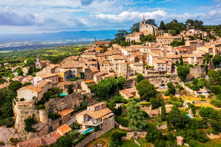
a. Height is the whole point
Where Lacoste feels closed-in, Bonnieux is open and full of sky. It rises from about 200 meters at the valley edge to over 425 meters at its crest, so working your way up means climbing through layers of history toward a wide view.
b. Climb to the old church
The heart of a Bonnieux visit is the walk up to the Vieille Église at the summit. Along the way and at the top:
- Flights of outdoor stone steps and grand old townhouses.
- A summit shaded by mature cedars and pines.
- A church blending Romanesque and Gothic work over several centuries.
- A terrace view taking in Lacoste, Gordes, Roussillon, and Mont Ventoux.
c. Understand the two churches
Bonnieux is unusual for having two prominent churches at very different heights:
- The upper church served the old fortified village at the summit.
- The lower church was built between 1866 and 1870 near the valley road.
By then, climbing hundreds of steps daily had grown hard for an aging population drifting downhill. The pair neatly shows how the village grew and shifted over time.
d. History that runs deep
Bonnieux was an important papal town, answering to the Popes in Avignon and Rome from 1274 until the Revolution. Papal privileges and tax breaks helped build the fine stone houses you see in the center.
e. The Roman bridge nearby
Down on the valley floor stands Pont Julien, a Roman bridge traditionally dated to 3 BC. Think of it as context, not a separate stop:
- It carried the Via Domitia, the great road linking Rome to Spain.
- It is a three-arched limestone bridge with openings to let floodwater pass.
- It carried road traffic right up until late 2005.
It proves this land was a major travel corridor two thousand years ago.
f. Small things to notice
- Carved keys of Saint Peter above doorways, marking former papal properties.
- The Musée de la Boulangerie, set in a building with historic ovens.
- The view back to Lacoste, showing how closely the two towns watched each other.
Next, cross to the softer south. The road threads through the Combe de Lourmarin, the only natural pass through the range.
10. Lourmarin – Change the Pace With Renaissance Architecture, Galleries and Literary Provence
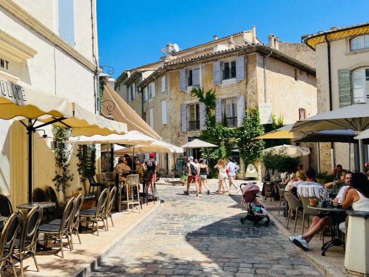
a. Where the mood relaxes
Lourmarin is where you slow down and breathe out. Listed among Les Plus Beaux Villages de France, it is the cultural hub of the South Luberon: open, artistic, and easygoing, set among olive groves and plane trees. Expect wide lanes, fountains, café terraces, and galleries instead of ramparts.
b. Start with the château
At the western edge stands the Château de Lourmarin, often called the first Renaissance château in Provence. It reads as two buildings joined:
- A medieval wing with thick walls and late Gothic detail.
- A Renaissance wing with an open double-spiral staircase, wide windows, and a columned loggia.
Unlike the defensive castles earlier on the route, this one was built for comfort and display.
c. The rescue story
By the early twentieth century the château had fallen into ruin. It was saved by Robert Laurent-Vibert, a scholar from Lyon, who bought and restored it in 1920. After his death, it became a foundation, and since 1927 it has run as an artist residency with a summer chamber music series. That is why the village still feels so creative.
d. Give the village center equal time
Do not stop at the château. The old center rewards a slow wander:
- Fountains all through the village, including the carved Fontaine aux Trois Masques.
- Three landmark bell towers: the belfry (the Castellas), the church tower, and the Neoclassical Protestant Temple.
- Streets lined with craft shops, perfumeries, and café tables.
e. The literary side
Lourmarin is closely tied to Albert Camus, who won the Nobel Prize in 1957. Worth knowing:
- He loved the village’s light and bought a house here in 1958.
- He is buried in the village cemetery under a simple slab.
- The novelist Henri Bosco, who wrote of the Luberon, lies nearby.
These writers are part of a wider artistic character, not the whole of it.
Next, head into working village life. The road runs east through vineyards to a farming village built around a large, shaded water basin.
11. Cucuron – Center the Story on the Plane Tree Basin, Then Uncover the Fortified Village Around It
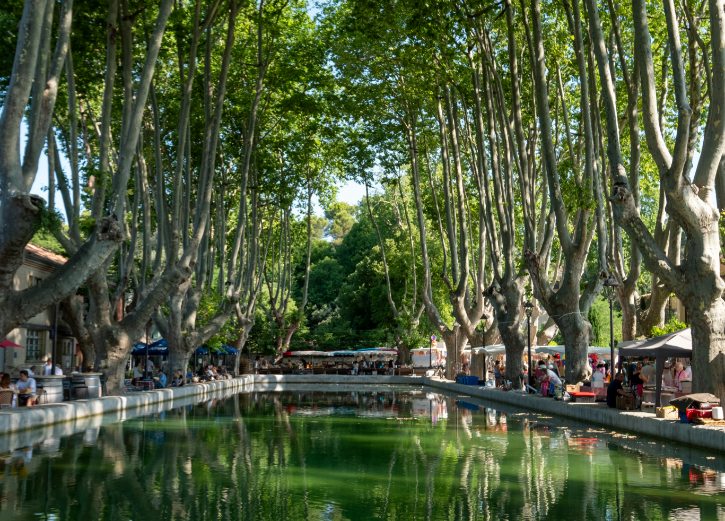
a. Why it stays with you
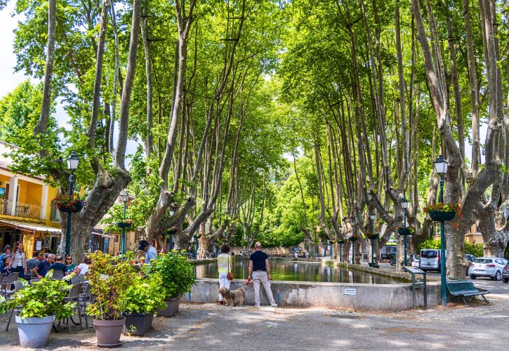
Cucuron makes a memorable first impression, and it is not a castle or a cliff. The edge of the old quarter is dominated by the Bassin de l’Étang, an open-air stone reservoir ringed by tall plane trees. Calm water reflecting old houses gives a scene unlike anywhere else on the route.
b. Understand the basin
The basin looks purely scenic today, but it began as serious infrastructure:
- A rectangular stone reservoir, about 61 metres long and 13 metres wide.
- Recorded as early as 1403 and bought by the town in 1515.
- Built to store water that turned flour mills lower down the hill.
In the nineteenth century, when the mills fell idle, the basin was lined with stone and planted with plane trees, turning old machinery into a gathering place.
c. Explore the fortified village
Step past the water and you enter a defensive place, once ringed by three sets of walls. Look for:
- Sections of medieval rampart and towers.
- The Tour Sus-Pous, an open-backed tower that let defenders receive supplies.
- The resquiau beside it, a stone slope worn smooth by children sliding.
d. Find the drawbridge gate
At the corner of the basin stands the Portail de l’Étang, built in 1541. It rewards a close look:
- Two parallel vertical slits are cut high above the arch.
- They once held the beams and chains of a working drawbridge.
- The gate helped defend the town during the Wars of Religion.
Knowing what those slots are turns a plain gate into living history.
e. The church and the donjon
Uphill stands Notre-Dame de Beaulieu, mixing a Romanesque nave with a Gothic choir and a 1614 organ. Its raised forecourt makes a natural viewpoint over the rooftops. Above the village rises the Donjon Saint-Michel, the last keep of the old castle. One important note: its upper terrace is permanently closed for safety, whatever older guides say, though footpaths circle the base with fine views.
f. The route’s quirkiest detail
Above Rue du Marché, the Tour de l’Horloge carries an unusual ornament beneath its cross: a wrought-iron insect called the Barbarota, meaning the wheat weevil. Local tradition says it was fixed high on the belfry as a charm to keep pests out of the town’s granaries. It is a small, funny touch you will not find anywhere else.
Next, follow the vines to a castle village. An isolated hill rises from the vineyards, crowned by Ansouis and its château.
12. Ansouis – Finish With Caladed Lanes, Fortified Architecture and a Château That Evolved From Stronghold to Pleasure Residence
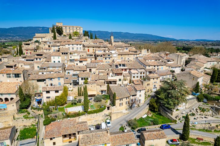
a. A fitting final stop
Ansouis draws together nearly every thread of the route: a perched setting, dry limestone lanes, deep religious architecture, and old walls, all crowned by a château. Listed among Les Plus Beaux Villages de France, it wraps around the rock in rings of stone streets, reading as one complete ensemble rather than just a castle with houses beneath it.
b. The château as the climax
The Château d’Ansouis is the visual center of everything. Be precise about its age:
- A fortified post stood on this hill as early as the tenth century.
- The earliest castle in the records is not the building you see today.
- The keep and towers of the surviving château date from the twelfth and thirteenth centuries, with major later changes.
For centuries it belonged to the noble Sabran-Pontevès family.
c. From fortress to comfortable home
The most interesting thing here is how the castle changed. From the seventeenth century onward, the family softened the fortress into a residence:
- Thick walls were opened with large classical windows.
- Rooms were refined with plasterwork, carved fireplaces, and fine furniture.
- Where ditches once stood, formal French gardens were laid out with hedges, fountains, and valley views.
You can read the shift from defense to comfort in the building itself.
d. The church of Saint-Martin
Beside the château stands Église Saint-Martin, a rare church built into the town’s defenses. Look for:
- A semi-circular forecourt reached by a curved flight of ten steps.
- A fortified south wall, about two meters thick, that doubled as a rampart.
- Narrow arrow slits, some later sealed once the danger passed.
- A nave under a pointed barrel vault, with the choir bending to fit the castle rock.
e. Details to hunt for
- Mason’s marks inside the church, small crosses and initials cut for payment.
- Carved corbels shaped as human heads and animals.
- The village washhouse at the base of the village, fed by spring water.
As you descend, watch how grand buildings up top give way to humbler, everyday ones below.
f. Where the road trip comes together
Ansouis was a full community, with a sixteenth-century town council house and a seventeenth-century charitable brotherhood, not just a castle and its cottages. Walking down its lanes with the Durance valley below brings the whole route to a natural close.
Think back over the journey. It began beside the flowing Sorgue, followed the river to its source, crossed dry-stone country and a plague wall, slipped into a silent monastery valley, climbed Gordes and hidden Goult, glowed through the ochre of Roussillon, brooded over Lacoste, opened wide at Bonnieux, relaxed in Lourmarin, and gathered around the plane trees of Cucuron.
That is the real gift of these twelve towns. They are close enough to link into one easy trip, yet each one changes the geology, the color, and the mood just enough that the drive never feels the same twice. You do not just visit twelve pretty places. You watch Provence quietly change around you, one short stretch of road at a time.