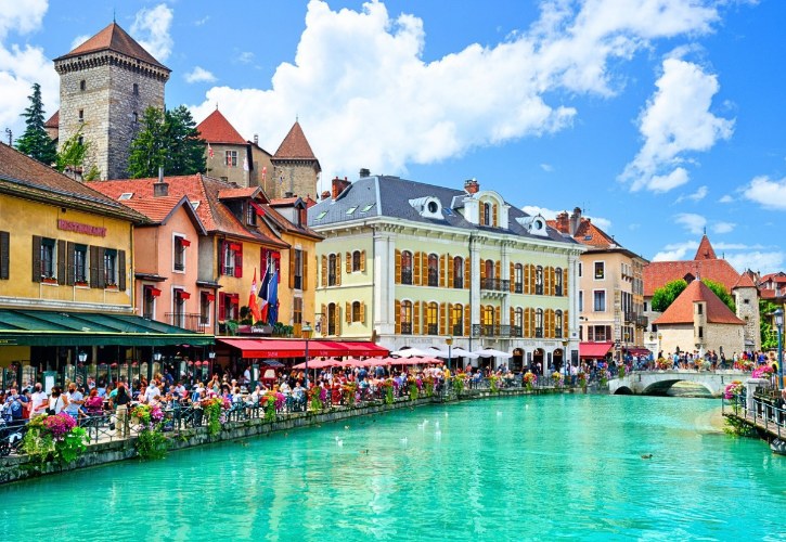
Lake Annecy sits in the French Alps, where clear blue water meets steep peaks and quiet villages.
Driving its shoreline lets you take it all in, with calm waterfronts, historic landmarks, and alpine views one after another.
The stops link into a natural loop, so every bend hands you something new. Take your time and let the lake set your pace. 😊
1. Annecy
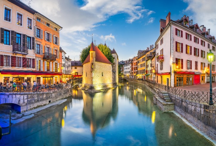
a. The Old Town Known as the “Venice of the Alps”
You start your loop in Annecy’s Old Town, one of the most recognizable corners of the French Alps. Its medieval streets, pastel buildings, and canals grew up around the Thiou, the river that drains the lake toward the Fier.
Two landmarks anchor the historic center:
- Palais de l’Île. A fortified stone building on a small island in the middle of the Thiou, with a pointed prow that splits the river. It dates to at least 1132 and has been a home, a courthouse, a mint, and a prison. Today it is a heritage and architecture center.
- Château d’Annecy. Perched on a rocky spur, this was the seat of the Counts of Geneva. Inside you will find the castle museum and terrace views over the rooftops and the northern lake.
b. Green Spaces Between the Town and the Water
Between the medieval streets and the open lake sit two parks made for a slow stroll:
- Jardins de l’Europe. A leafy peninsula from the 1860s, now holding more than 600 mature trees, including century-old giant sequoias. Shaded paths follow the water, with views toward Mont Veyrier.
- Le Pâquier. A wide 7.5-hectare meadow along the northern shore, with open lawns and an unbroken view of the lake and the peaks.
These are the best spots to relax on the grass, watch the sailboats, and enjoy the setting between the mountains and the water.
c. The Lovers’ Bridge and the Bell Towers Above
The Pont des Amours, or Lovers’ Bridge, is one of Annecy’s most photographed landmarks. Stand in the middle for two very different views:
- Looking inland, the Canal du Vassé runs beneath a tunnel of century-old plane trees, with wooden boats along the quays.
- Looking out, the water opens toward Mont Veyrier, the Dents de Lanfon, and La Tournette.
Historic bell towers rise over the skyline too, including the Gothic Église Saint-Maurice, the Renaissance Cathédrale Saint-Pierre, and the Basilique de la Visitation, whose tower climbs 72 meters on the Semnoz.
d. Markets, Cafés, and Everyday Savoyard Life
On Tuesday, Friday, and Sunday mornings, open-air markets fill the Old Town. This is the place to taste the region:
- Local cheeses like Reblochon, Chevrotin, and Beaufort.
- Cured mountain charcuterie.
- Fresh lake fish such as Arctic char and whitefish.
Between the waterside cafés and bakeries sit quiet alleys most visitors miss. From here, the road continues toward the calmer shoreline of Plage d’Albigny.
2. Plage d’Albigny
a. A Wide Meadow Beach Dressed in Flowers
Plage d’Albigny is the largest free public beach on Lake Annecy, running about 400 meters along the northern shore. Instead of coarse pebbles, it offers broad, soft lawns. Here is what gives it that easy, open feel:
- Grassy lawns shaded by weeping willows and poplars.
- Seasonal flower beds dotted through the green.
- A wide view south across the broadest part of the lake, with the Semnoz and the distant Bauges range behind.
b. Gentle Water That Families Love
Locals often call this the top family swimming spot on the northern basin, and the shoreline shows why:
- The water’s edge has a clean band of fine sand and soft sediment, without sharp pebbles.
- The bottom slopes very gently, so you can wade out a good distance in shallow water.
- Marked swimming areas are watched by certified lifeguards in July and August.
- Free floating chairs, called Tiralo, help visitors with reduced mobility reach the water.
c. What to Enjoy Along the Waterfront
Even if you would rather sightsee than swim, there is plenty around the beach:
- The Petit Port marina shelters sailing dinghies and small motorboats.
- Rentals nearby include electric runabouts, classic pedalos, and paddleboards.
- Refreshment kiosks, ice cream stands, and dining terraces line the waterfront.
- The elegant Impérial Palace, a Belle Époque estate, sits in a wooded park just back from the lawn.
d. Following the Shore Toward Veyrier-du-Lac
Leaving the beach, the road follows the lakeshore onward. A wooden boardwalk on stilts reaches out over the water for about 400 meters, letting you walk just above the shallows with the peaks ahead.
As you go, the open parkland gives way to a quieter shore of villas and stone boathouses. The cliffs of Mont Veyrier rise sharply above the road, setting the scene for a more intimate, mountain-backed village.
3. Veyrier-du-Lac
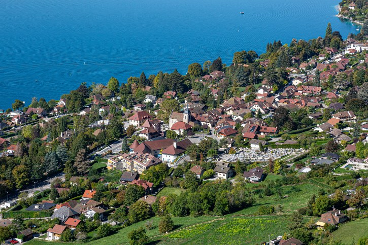
a. A Quiet Village Tucked Beneath the Mountain
Veyrier-du-Lac sits right at the western foot of Mont Veyrier, which rises to 1,291 meters. Sheltered from the cold northern winds, it enjoys a sunny southwest exposure through the afternoon and evening.
That gentle light has long drawn admirers, from landscape painters to the Nobel physicist Louis Néel, who lived here. What sets it apart from busy Annecy is its calm, residential feel, with narrow streets winding above the widest part of the lake.
b. The Blue Flag Beach and the Water Sports Base
The star of the shoreline is Plage de La Brune, which has held the European Blue Flag eco-label every year since 2009 for its clean water and careful management:
- An open, sunny meadow of soft grass fringed by a clean strip of natural sand.
- A bottom that slopes gently into clear, shallow water, good for young children.
- Lifeguards on duty in July and August.
- Amphibious wheelchairs, showers, and a launch corridor for kayaks and paddleboards.
A little farther south, the quieter Plage du Plant offers a calm lawn, and the village nautical base runs sailing, windsurfing, and paddleboarding.
c. High Trails With Big Rewards
Mont Veyrier offers some of the finest high views over the lake, but these are real mountain trails, not easy strolls:
- The main route climbs from the village or the Col du Pré Vernet to the crest, and on to Mont Baron at 1,299 meters.
- From the lakeshore, expect more than 800 meters of sustained ascent over rocky switchbacks and roots.
- Bring sturdy footwear and good fitness, and take real caution in wet weather.
- The old summit cable car was removed in 2001, so the top is reached only on foot.
The payoff is a sweeping view down the full length of the lake, and on clear mornings you can even spot the glaciers of the Mont Blanc range.
d. The Calm Heart of the Village
Away from the water, the village center holds a quiet charm of its own:
- The Église Saint-Maurice, with Romanesque foundations and a Savoyard bell tower.
- Stone houses with vaulted cellars that recall the winegrowing past.
- The Quai du Général Doyen, where the marina shelters sailboats and wooden barques beneath plane trees.
- Lakeside bistros that set their terraces right over the water.
For a slower, more intimate stop, Veyrier-du-Lac is hard to beat. From here the road leads on to the hilltop castle at Menthon-Saint-Bernard.
4. Port and Château de Menthon-Saint-Bernard
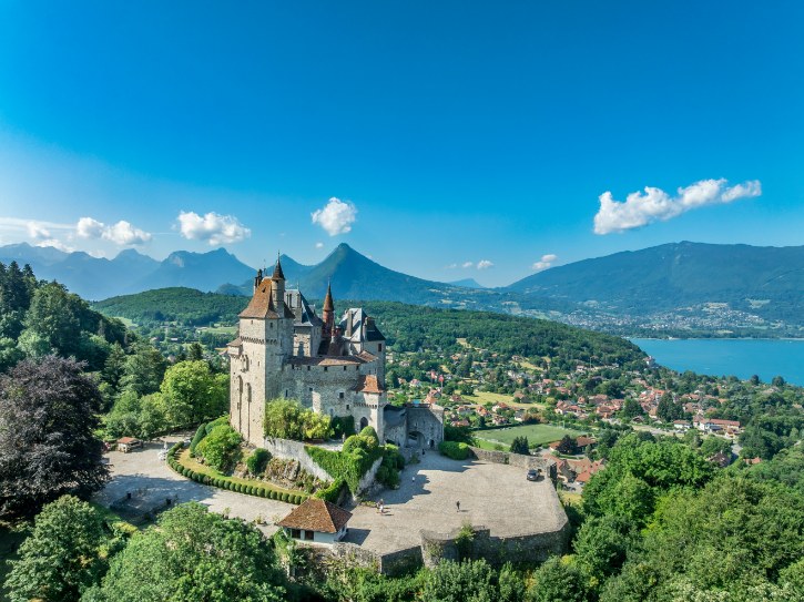
a. A Fairy-Tale Castle on Its Limestone Hill
The Château de Menthon-Saint-Bernard crowns a steep knoll about 200 meters above the water, one of the most striking sights in the French Alps. First fortified in the late tenth century, it is remarkable for its continuity, as the noble Menthon family has held it for roughly a thousand years.
The castle grew in three main stages:
- A stern medieval fortress of square towers and curtain walls.
- A Renaissance makeover into a noble residence with grand halls.
- A neo-Gothic overhaul in the late nineteenth century, adding the slender turrets and steep slate roofs that give it a fairy-tale look today.
A popular story says Walt Disney drew inspiration from this castle for the Sleeping Beauty Castle. It often comes up alongside Bavaria’s Neuschwanstein, but it remains a legend rather than a confirmed fact.
b. Inside a Thousand Years of Family History
The château holds 105 rooms across four levels, several open on guided tours:
- The library holds more than 12,000 volumes from before 1800, including medieval manuscripts.
- The Countess’s Bedroom and Grand Salon keep period furniture, tapestries, and carved timber ceilings.
- The thirteenth-century kitchen still has its huge fireplaces and an early system that carried hot dishes upstairs.
The estate also honors Saint Bernard of Menthon, patron saint of mountaineers, and Count François de Menthon, a Resistance figure and French prosecutor at the Nuremberg trials.
c. The Peaceful Port Below the Castle
Down at water level, the Port de Menthon-Saint-Bernard has a calm, welcoming feel. It is an easy place to relax and photograph the boats:
- The harbor shelters sailing boats and classic wooden craft behind stone breakwaters.
- A plane-tree-shaded esplanade runs along the water with benches facing the lake.
- The grassy Plage Municipale next door offers shaded lawns, diving pontoons, and a children’s wading area.
- The grand Palace de Menthon hotel adds a touch of elegance along the shore.
d. Views From the Heights and the Shore
From the castle terraces, you look southwest toward the wooded Roc de Chère, then east to the jagged Dents de Lanfon at 1,824 meters and La Tournette at 2,351 meters, the tallest peak around the lake.
From the port below, your eye runs across to the cliffs of Mont Veyrier and the castle peninsula of Duingt. From here the road winds around the forested Roc de Chère and drops into the sheltered bay of Talloires.
5. Baie de Talloires (Talloires)
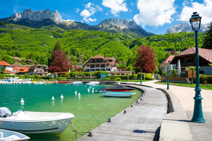
a. One of the Loveliest Bays on the Lake
The Baie de Talloires curves like a natural amphitheater along the eastern shore. Shielded on the north by the forested Roc de Chère, it stays calm and mirror-like, reflecting the peaks all around.
Red-tiled rooftops, waterfront gardens, and turquoise water sit against a dramatic mountain backdrop. From the village quays, you look straight across the narrows toward Duingt. It is genuinely one of the lake’s most memorable scenes.
b. An Abbey and the Painters Who Came Here
At the village heart sits the Abbaye de Talloires, a Benedictine foundation whose roots reach back to 1018. Later turned into a celebrated hotel and dining retreat, it has welcomed famous guests over the years:
- Winston Churchill and Mark Twain both stayed here.
- The painter Paul Cézanne spent the summer of 1896 at the abbey and painted his well-known Le Lac d’Annecy, now in London’s Courtauld Gallery.
As you wander, keep an eye out for the eighteenth-century Église Saint-Maurice, old stone fountains, and villa gardens draped with wisteria and climbing roses.
c. Out on the Water and Up on the Ridge
The sheltered bay makes Talloires a natural base for the water or the hills:
- The local nautical club offers sea kayaking, paddleboarding, and rowing in the calm bay.
- The Plage Municipale has grass lawns, a diving pontoon, and a paddling area facing the Château de Duingt.
- Above the village, the Ermitage de Saint-Germain marks an eleventh-century retreat, with a stone belvedere over the bay.
- Just north, the 68-hectare Roc de Chère reserve has marked trails through oak and hornbeam woods.
- Overhead, paragliders drift down from the famous launch sites of Planfait and the Col de la Forclaz.
One useful note: the pilgrimage site of Notre-Dame du Lac is sometimes placed here by mistake, but it actually sits across the water above Duingt.
d. The Easy, Elegant Rhythm of the Village
Talloires has an elegant, unhurried pace. Shaded quays and wooden benches invite you to sit and watch the lake shift from pale emerald to deep sapphire as the light changes.
The village is also known for its food, from fine dining rooms to waterside bistros serving lake fish with crisp Savoyard white wines. After this refined stop, the road continues on into the quieter setting of Angon.
6. Angon
a. The Gentle Southern Edge of the Bay
The small hamlet of Angon lies along the southeastern shore, just below Talloires, with a more rural feel. The main draw is Plage d’Angon, set in a shaded park of willows and poplars:
- Broad grassy lawns edged by a natural pebble shoreline.
- A shallow mountain stream running through the grass, which makes a safe, shaded splashing spot for young children.
- Close-up views across the narrows toward the Duingt peninsula and the wooded Taillefer ridge.
It has a relaxed, uncommercialized feel that suits picnics, casual swims, and paddleboarding.
b. The Climb to a Hidden Waterfall
The big nature outing from Angon is the climb to the Cascade d’Angon, a waterfall that drops nearly 60 meters into a steep canyon. This is not a casual stroll, and it pays to be ready:
- The marked trail starts from the lakeshore parking area and climbs steadily through dense woodland.
- The lower paths are wide and manageable, but the rockier approach runs along a cliff face protected by railings.
- The rock near the falls stays wet and slick from constant spray all year.
- Sturdy footwear with good grip is essential.
- The trail is not advised for unsupervised small children, anyone with a fear of heights, or in icy winter conditions.
The same route also takes in the Pont des Fées, or Fairies’ Bridge, a natural arch spanning the mountain torrent, which many walkers link with the waterfall on a loop.
c. Hillside Views Over Old Vineyard Terraces
The wooded slopes above Angon open onto wide views across the southern end of the lake. Paths climbing toward the hamlet of Vérel reveal the full length of the Petit Lac, the Doussard marshlands, and the pyramid-shaped Montagne d’Entrevernes.
These warm, south-facing hillsides were once terraced for vineyards, which villagers from Duingt rowed across to tend. After the vine disease of the late nineteenth century, the vineyards disappeared, leaving old stone terrace walls, orchards, and woodland behind.
d. Quiet Nature Before the Southern Tip
Today the setting is all quiet nature, streams, and mountain views. It is a peaceful favorite for a few reasons:
- The hamlet stays well off the main tourist flow.
- The footpaths down to the water are shaded and calm.
- The elevated views over Talloires Bay reward even a short climb.
From here the road reaches the far tip of the lake at Doussard.
7. Doussard
a. Where the Lake Meets the Wetlands
At the southern end of the lake, Doussard feels different from everywhere else on the loop. Here the deep alpine trench opens into a broad valley framed by the Bauges to the west and the Bornes to the east.
Two mountain rivers flow in, creating a wide wetland of channels, reed beds, and damp woodland. To protect it, the French government created the Réserve Naturelle Nationale du Bout du Lac d’Annecy in 1974. Covering about 84.5 hectares, it is the last intact wetland of its size on the lake and a natural filter for the water. After the towns and castles farther north, this wild landscape is a lovely change of pace.
b. A Boardwalk Through Living Marshland
The reserve has an easy nature trail designed to let you explore while protecting the marsh:
- A wooden boardwalk and flat gravel path wind through flooded alder forest and marshland.
- The route is barrier-free and friendly to strollers and visitors with reduced mobility.
- Interpretive panels explain how the wetland works.
- Along the way, the historic Tour de Beauvivier, a roofless medieval ruin, has a metal staircase that lets you climb to the top for a view over the reeds and the lake.
Among the wildlife you might notice signs of are European beavers, reintroduced here in 1972, nesting water birds like the great crested grebe, and amphibians such as the alpine newt.
c. Swimming, Paddling, and Paragliders Overhead
Just outside the reserve, Doussard keeps a lively waterfront. The open southern shore feels more spacious than the enclosed bays up north:
- The municipal beach, Douss’plage, has wide grassy lawns and natural sand, with supervised summer swimming and picnic areas.
- Operators at the Port de Doussard rent paddleboards, kayaks, and small catamarans, with channels that keep boats clear of the bird sanctuary.
- Doussard is famous as the main landing zone for paragliders coming down from the Col de la Forclaz and Planfait, filling the sky with color on sunny afternoons.
d. The Long View Back Up the Lake
Look north from Doussard and you see the entire length of the lake stretching away, flanked by Mont Veyrier and the Semnoz, with Annecy’s skyline visible on clear days.
The mix of quiet marshes, slow river channels, and steep mountain walls makes this a calm, photogenic contrast to the busier resort villages. From here the route curves around and traces the far shore toward Duingt.
8. Duingt and Château de Duingt
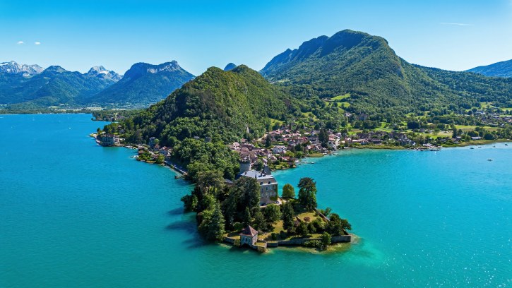
a. The Castle on the Water’s Edge
The Château de Duingt, also known as the Château de Châteauvieux or Château de Ruphy, reaches into the water on a slim peninsula at the narrowest point of the lake. Founded in the eleventh century as a medieval fortress on what was then an islet, it was later remodeled over the centuries and now sits on a peninsula rather than a true island.
The château is privately owned and closed inside. Even so, it is a wonderful landmark to admire and photograph from several public spots:
- The Duingt municipal beach, right at water level.
- The village harbor promenade.
- Marked hiking paths along the Taillefer ridge above the village, for the elevated view.
b. Wandering the Pearl of the Lake
Inland from the castle, the village of Duingt keeps a peaceful, traditional character, and its old center follows narrow medieval lanes. As you wander, look for:
- Seventeenth- and eighteenth-century stone farmhouses.
- Carved wooden balconies and old communal washhouses.
- Stone door lintels engraved with historic crests.
- The Église Saint-Germain, a neo-Gothic church inaugurated in 1903, with historic statues and stained glass.
c. A Second Castle in the Valley
A short way inland, along the Route d’Entrevernes, stands the Château d’Héré, built in the fifteenth century as a fortified manor. A few details make it worth a look from the road:
- Square defensive towers and mullioned stone windows.
- Historic interior wall frescoes.
- Listed as a historic monument since 1984.
Like the lakeside castle, it is private and closed to visitors, but its silhouette is easy to admire. That concentration of medieval buildings gives Duingt its romantic, layered heritage.
d. The Viewpoint Above the Village
The best public viewpoint around Duingt is the Grotte et Belvédère de Notre-Dame du Lac, on the wooded Taillefer slopes above the village. It carries a touching backstory: in December 1854, two boatmen caught in a winter storm prayed to the Virgin Mary and were saved, and in thanks the community built a grotto and statue on the cliff.
A steep footpath lined with small stone shrines climbs for about 20 to 30 minutes to reach it. From the belvedere, you look down over the village rooftops, the castle peninsula, and the sheer face of La Tournette across the water. From here the road continues on toward Saint-Jorioz.
9. Plage de Saint-Jorioz
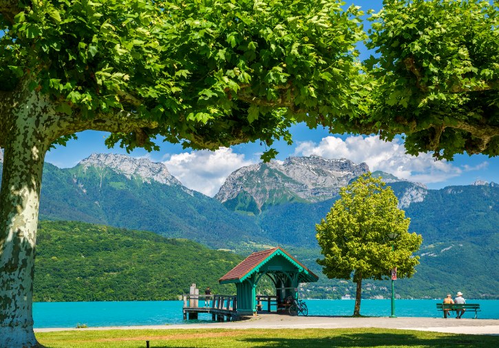
a. A Rare Stretch of Sandy Shore
Set on the delta of the Laudon river, the Plage Municipale de Saint-Jorioz is one of the finest beaches on the lake. While many of the lake’s beaches are grass or pebble, this one is known for its wide stretch of fine, pale sand:
- Sunlit sand right at the water for swimming.
- Tree-shaded lawns just behind for relaxing out of the heat.
- A wide wooden diving pontoon, launching jetties, and marked swimming zones.
The mix of open sand and shade makes it an easy favorite for families and anyone wanting a comfortable day by the lake.
b. The Grandest Mountain View on the Lake
Because it sits on the western shore, Saint-Jorioz offers what many consider the most dramatic mountain view on the lake. Look straight across and you face the full wall of the Bornes range:
- La Tournette, at 2,351 meters, rises directly opposite, soaring nearly two kilometers above the lake.
- To the northeast, the jagged spires of the Dents de Lanfon, at 1,824 meters, stand out against the sky.
- Opposite, the forested cliffs of the Roc de Chère frame the deep blue central bay.
Thanks to its western position, the beach also holds its sunshine well into the evening, long after the eastern villages fall into shadow.
c. A Blue Flag Beach Set Up for the Day
Saint-Jorioz has held the Blue Flag eco-label every year since 2010, a sign of clean water and careful management. The beach is well equipped for a full, easy day out:
- Lifeguards supervise the swimming area through the summer, with a shallow zone for younger children.
- Accessible features include paved ramps to the water, disabled parking, and free amphibious wheelchairs with staff on hand.
- Extras include beach volleyball, ping-pong, shaded playgrounds, and rinse showers.
- Snack kiosks and shaded restaurant terraces sit beside the sand.
d. The Relaxed, Residential Side of the Village
For all its facilities, Saint-Jorioz still feels relaxed and residential. Away from the sand, the Sentier des Roselières, or Reed Bed Path, winds through protected lakeside marsh, where you can watch nesting water birds and wetland plants without going in the water.
The whole area feels spacious and natural, a good place to slow down before the final leg toward Sévrier.
10. Sévrier
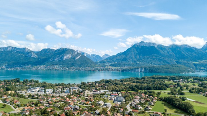
a. A Western Shore Facing the Peaks
On the northwestern shore, Sévrier stretches along a ribbon of waterfront at the base of the Semnoz, directly opposite Veyrier-du-Lac and the Dents de Lanfon. The village has two main public beaches:
- Plage Municipale de Sévrier, a modern beach of fine sand and manicured grass shaded by willows, with gentle shallow water, marked swimming zones, summer lifeguards, and dining terraces.
- Plage des Choseaux, a quieter neighborhood beach of grass and pebble, better for a peaceful stop away from the crowds.
The Port de Sévrier nearby keeps the waterfront lively with motorboats, sailboats, and traditional barques.
b. Morning Light Across the Water
Facing northeast, Sévrier catches lovely light through the day. In the early morning, the sun comes up over the Dents de Lanfon and Mont Veyrier, casting golden light and crisp reflections across the glassy water. From the quays and the stone jetty of the Ponton des Seines, the views open up all around:
- Northeast, the limestone wall of Mont Veyrier drops straight to the eastern shore.
- East, the Dents de Lanfon cut a jagged profile against the sky.
- South, the narrows near Duingt and the bulk of La Tournette close off the horizon.
- West, the pine-covered slopes of the Semnoz, at 1,699 meters, rise right behind the village.
c. One of the Lake’s Liveliest Water Sports Hubs
Sévrier is one of the lake’s busiest spots for getting out on the water, with a long nautical tradition. The local sailing academy runs catamaran and dinghy training, and the wide bay suits paddleboarding, kayaking, water-skiing, and windsurfing. A few rules protect the lake, and they are worth knowing:
- Motorboats must keep to a slow 5 km/h within the protected shoreline band.
- Water-skiing and wakeboarding are restricted to set offshore zones and hours.
- Jet skis are banned across the whole lake to keep it quiet and clean.
Sévrier has one more claim to fame in the Fonderie Paccard, a bell foundry founded in 1796, with a museum showing centuries of bronze casting exported around the world.
d. A Fitting Finish to the Loop
Sévrier makes a satisfying last stop before the circle closes. A paved lakeside promenade links the port and beaches to the historic Ponton des Seines, where you can sit under plane trees and watch the sailboats drift by against the mountains.
From here the return to Annecy is quick and smooth, following the shore back toward the Old Town canals. Completing the circle shows how much Lake Annecy packs into one shoreline: medieval streets and hilltop castles, sheltered bays and wild wetlands, a romantic peninsula and broad sandy beaches, all wrapped in beautiful alpine scenery. Trust me, by the time you roll back into Annecy, you will already be planning your next lap.