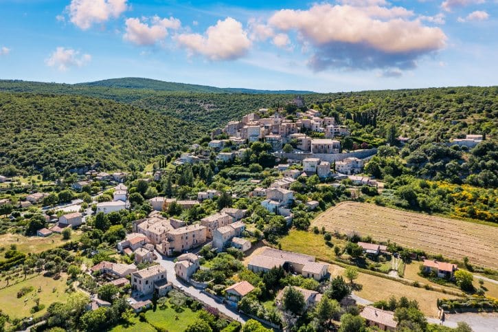
Most first-time trips to Provence circle the same famous names. Gordes, Roussillon, Aix-en-Provence, and Saint-Rémy-de-Provence draw the crowds, and they earn it.
But the region is far bigger than its greatest hits. Just beyond those stops sit atmospheric villages, dramatic cliffs, historic streets, and hilltop settlements that rarely make a first itinerary.
Some even carry official recognition. They are simply less known to international travelers, and well worth your time. 😊
1. Saignon, a rock-crowned village above the Apt valley
a. Why it’s worth your time
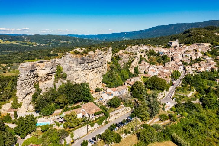
If you’re already in the Luberon for Gordes or Ménerbes, Saignon is an easy, rewarding add. It sits at around 500 meters on the edge of the Grand Luberon, above the Calavon valley.
Its signature is the Rocher de Bellevue, a 35-meter block of rock that rises above the houses and makes the whole village look like a natural fortress from below. It’s not undiscovered, just a little off the main D900 road, so tour buses tend to skip it. That’s why it stays so quiet.
b. What to see
- Place de la Fontaine. A shaded square with an 19th-century stone fountain, a natural place to start.
- Rue de l’Horloge and the calades. Stone lanes that climb through the Porte de l’Auro, a medieval archway from the old ramparts.
- Notre-Dame-de-Pitié. An 11th- and 12th-century Romanesque church with a carved portal and pyramidal bell tower, once a stop on the Via Domitia pilgrimage route.
- The castle traces. Three feudal castles once stood on the rock. Today you can spot carved steps, wall foundations, and rock-cut cisterns in the stone.
- Rocher de Bellevue. The climax. A short climb up rock-hewn steps reaches a 360-degree view, with an orientation table to name Mont Ventoux, the Southern Alps, and the plain toward Avignon.
c. How long to stay
Don’t rush this one. To get the most from it:
- Wear sturdy shoes for the steep steps, and take care near the exposed summit edges.
- Come in late afternoon, when the light warms the rock and the valley below.
- Time it for the Thursday morning market (April to September) for local cheese, produce, and honey.
- Add a walk onto the Plateau des Claparèdes, with its dry-stone huts and summer lavender.
Plan a relaxed half day, around 3 to 4 hours, so you can wander the lanes, climb the rock, and linger at a café rather than dash through.
2. Goult, the Luberon village whose own tourism office calls it “hidden”
a. Why Goult gets overlooked
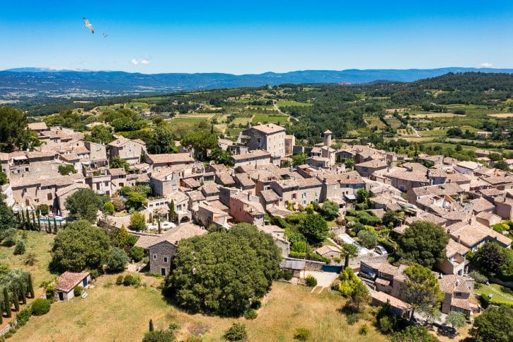
Goult sits on a sandstone hill facing Gordes, Roussillon, Bonnieux, and Ménerbes, yet most people drive right past. Its own tourism office is honest about it, calling Goult a “village caché en Luberon”, a hidden village of the Luberon.
It sits just back from the busy D900 and has no single world-famous monument, so fast trips skip it. What you get instead is dry-stone architecture, quiet medieval lanes, and working farm terraces.
b. What to see
- Place de la Libération. The village heart, shaded by old hackberry trees and lined with cafés.
- Église Saint-Sébastien. A 12th-century Romanesque church with a baroque altarpiece and Provençal vaulting.
- Rue du Jeu de Paume and Rue de la République. Climbing lanes with limestone walls, ochre render, vaulted passages, carved lintels, and old washhouses.
- Moulin de Jérusalem. A restored 17th-century windmill, Goult’s landmark, with long views toward Gordes and the Monts de Vaucluse.
- Conservatoire des Terrasses de Culture René Richard. Dry-stone farm terraces built without mortar, with paths past walls, cisterns, and shelters.
A little history helps: Goult grew around a feudal castle under the powerful d’Agoult family, and its terraces are the legacy of centuries of farming olives and crops in a dry climate.
c. How long to stay
Goult rewards slow wandering over a checklist:
- Follow the local old village walking circuit to catch corners you’d otherwise miss.
- Combine the center, the windmill, and the terraces, then add a café stop.
- Come on Thursday morning for the weekly market of goat cheese, honey, and olive oil.
Give it a half day, roughly 3 to 4 hours. With the terrace walk and a relaxed lunch, there’s far more here than a quick loop suggests.
3. Cucuron, plane trees, a historic water basin and layered fortifications
a. Why Cucuron belongs on your list
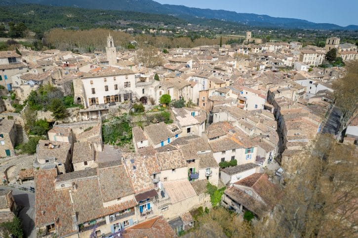
Cucuron sits on the southern slopes of the Grand Luberon, ranked among the most authentic, lived-in villages of the area. Unlike the classic hill villages, it spreads across a gentle rise, which gave it wider public spaces and one unusual feature.
That feature is the Bassin de l’Étang, a large water basin ringed by giant plane trees. Reflections, café terraces, and old façades make it one of the most relaxed scenes in the Luberon.
b. What to see
- Le Bassin de l’Étang. Created in the 14th century to power mills; its plane trees, planted in 1813, form a green ceiling over the water.
- Portail de l’Étang. A medieval stone gatehouse into the fortified center.
- The old lanes. Narrow streets with door knockers, carved lintels, fountains, and vaulted passages.
- Tour Sus Pous. A round tower with a sloped base and 16th-century gun ports.
- Donjon Saint-Michel. The last tower of the medieval castle, with a panorama over rooftops, olive groves, and the Durance valley.
Cucuron’s layout tells a story of three successive rings of ramparts, from the 11th-century castle down to the well-preserved 15th-century outer wall you still walk through today.
c. How long to stay
- Use the basin as your calm start or finish, and work the streets and viewpoints in between.
- Time it for the Tuesday morning market around the basin, one of the prettiest in the Luberon.
- Add the walk out to the Ermitage de Cucuron for elevated countryside views.
Plan a half day, about 3 to 4 hours. A long lunch under the plane trees plus the Ermitage walk turns a short stop into a proper, unhurried visit.
4. Venasque, an ancient religious site on a rocky Comtat Venaissin spur
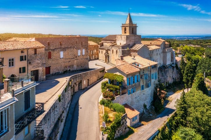
a. Why Venasque deserves a stop
Venasque perches on a steep crag above the Nesque valley. It’s an official member of Les Plus Beaux Villages de France, so it isn’t unknown, just less visited by international travelers than the big Luberon names. It even gave its name to the Comtat Venaissin, the historic papal territory that lasted until the Revolution.
b. The “baptistery”, and what it really is
Its famous monument is often sold as a “6th-century baptistery”. The truth is more interesting:
- Construction was multi-phase, beginning in Late Antiquity (roughly the 4th to 6th century) on Roman foundations, then heavily reworked in the 11th to 13th centuries.
- Its likely original role was an early Christian sanctuary, an episcopal or funerary chapel, later adapted for baptism.
- It’s still called the Baptistery of Venasque by tradition, but experts now describe it as multi-functional.
Inside, look for the Greek-cross plan, four apses, reused Roman marble columns, and the central octagonal basin.
c. What else to see
- The rampart towers. Called the “Saracen Towers”, but their foundations are actually Late Roman, with medieval walls built on top in the 12th century.
- Église Notre-Dame. A 13th-century Romanesque church with a 15th-century Crucifixion painting.
- The village lanes. Calades, stone façades, and viewpoints over the valley and Mont Ventoux.
For the best view of Venasque itself, take the short cliff-edge walk just outside the southern ramparts.
d. How long to stay
- The historic core has some steep, uneven walking, so wear comfortable shoes.
- Save time for the panoramic cliff walk, which shows the village at its best.
Allow around 3 hours, more if you settle into a café. Venasque is compact, but with the ramparts, the church, and the outside walk, it fills a relaxed half-morning or afternoon nicely.
5. Simiane-la-Rotonde, a steep stone village beneath an extraordinary medieval keep
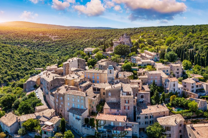
a. Why it stands out
Simiane-la-Rotonde sits in the western Alpes-de-Haute-Provence, where the soft Luberon gives way to higher, wilder plateaus. The village spirals up a steep hillside among lavender fields and oak woods, crowned by the 12th-century keep of the Château des Simiane, known as La Rotonde. Because it lies further east in a quiet area, standard Luberon routes miss it.
b. What to see
- The lower lanes. Steep cobbled paths with 16th- to 18th-century houses, carved door frames, and arched passages.
- La Halle. A historic covered market with stone columns and a timber roof.
- Château des Simiane. Grown from a 10th-century fort into the seat of the Simiane-Agoult family.
- La Rotonde. The highlight. Plain and defensive outside, but inside it opens into a two-story circular hall with a dome on twelve carved capitals showing figures, masks, plants, and beasts.
Historians read La Rotonde as a grand reception hall built to show off status, not just a military keep. From the top, wide views open over the plateau, grey stone against purple lavender in July and August.
c. History and living culture
- The village was once known for glassmaking, with workshops out in the woodlands.
- Today it’s tied to lavender and essential oil production.
- Each summer, La Rotonde hosts the Rendez-vous Musique Ancienne early music festival, its dome giving a beautiful natural resonance.
d. How long to stay
- The climb is genuinely steep, so start low and go slowly.
- Give the interior of La Rotonde and its capitals real attention.
Allow 3 to 4 hours. This is a place to linger over, so treat it as a longer, more absorbing stop than the smaller villages, ideally with a café pause partway up.
6. Banon, medieval lanes, a famous leaf-wrapped cheese and an extraordinary bookshop
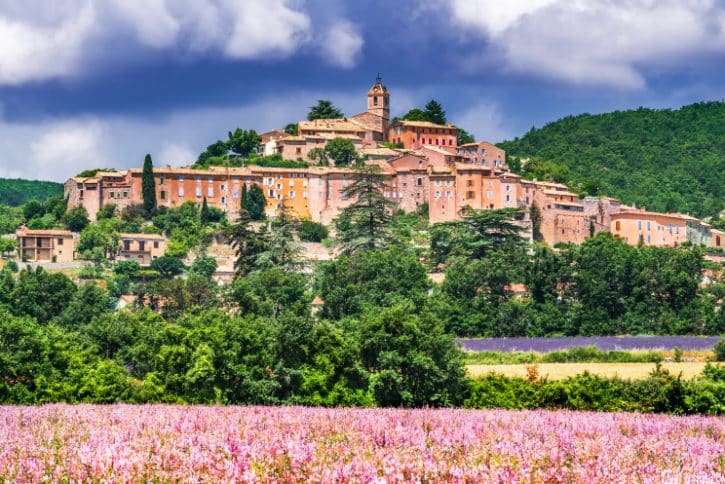
a. Why Banon is more than its cheese
Many people know Banon only for its cheese, which is exactly what makes it fun to explore. It sits at 760 meters between Mont Ventoux and the Montagne de Lure, with a cooler climate and a rural feel. Above the modern lower town rises a well-preserved medieval upper quarter, tied together by farming, food, and literature.
b. What to see
- Porte Féodale. A 14th-century gatehouse with a Gothic arch leads into the upper village.
- The upper lanes. Grey limestone houses, small staircases, ironwork balconies, and vaulted alleys.
- The church terrace. Wide views toward the Montagne de Lure and the Pays de Banon lavender fields.
c. Food and culture
Banon’s identity rests on three things:
- Banon AOP cheese. A protected goat cheese (verified via INAO), dipped in Marc de Provence and hand-wrapped in dry chestnut leaves tied with raffia. The wrapping keeps it moist and adds earthy, tannic notes.
- Le Bleuet. One of France’s largest independent rural bookshops, with over 110,000 titles across several floors. For many visitors, browsing here is a highlight.
- Jean Giono. The writer’s landscapes surround Banon, and his books capture the region’s rugged, farming soul.
d. How long to stay
- Start at Le Bleuet, climb through the Porte Féodale, reach the church terrace, then finish with a cheese tasting.
- Come on Tuesday morning for the market.
- Lavender colors the countryside in high summer; admire private fields from the edges rather than walking in.
Plan a relaxed half day, around 4 hours, so the village, the food, and the bookshop each get proper time.
7. Sisteron, the dramatic Durance gateway between Provence and the Alps
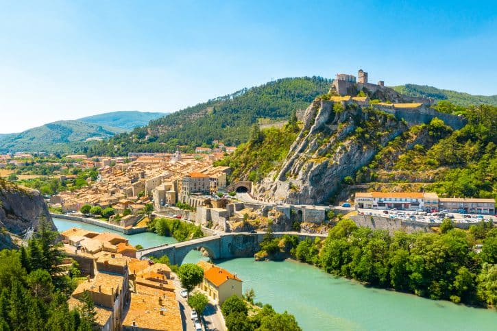
a. Getting the angle right
Sisteron isn’t hidden. It’s a well-known regional town, often called “La Porte de la Provence”, where lowland Provence meets the Southern Alps. But travelers who stick to the coast, the Alpilles, or the Luberon often miss it, and its mix of river, gorge, cliffs, and citadel looks like nothing else on this list.
b. Start with the landscape
- The Cluse de Sisteron. The Durance river squeezes through a narrow gap in a limestone ridge.
- Rocher de la Baume. A striking cliff of vertical folded limestone rising across the river.
- The fortress spur. The Citadel sits on a long ridge above the narrowest point, high over the town.
c. The citadel and old town
The Citadelle de Sisteron grew over centuries, so it’s far more than a “Vauban fortress”:
- A 13th-century keep and curtain wall.
- 16th-century Italian-style bastions for early artillery.
- Late-17th-century modifications by Vauban.
- 19th-century staircases cut into the bedrock.
Down in the town, don’t miss the Andrônes (steep covered passages), the 12th-century Cathédrale Notre-Dame-des-Pommiers, and four 14th-century round towers.
One piece of current news: the Citadelle reopened in March 2026 with a redesigned visitor route, new displays, and better access to the upper ramparts, including interpretation of its role in the Wars of Religion and the Second World War.
d. How long to stay
- The visit is physical: steep steps, cobbled ramps, and tunnels, so wear sturdy shoes.
- The best views come from the upper sections, and the orientation table at sunset is superb.
Give Sisteron a full half day, 4 to 5 hours. This is a place to explore properly, not a quick photo stop.
8. Briançon, spectacular and worthwhile, but not Provence proper
a. First, a quick geography note
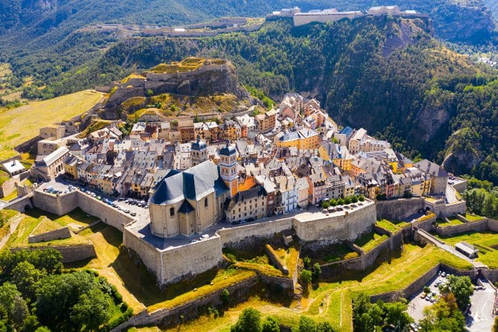
Briançon lies in the Hautes-Alpes, part of the modern Provence-Alpes-Côte d’Azur region, which is why it appears in regional guides. Historically, though, it belonged to the Dauphiné, not to historic Provence. So think of it as the mountain surprise inside a wider southern France trip, not as a Provençal town.
b. Why it still earns a place
- It’s the highest city in France, at 1,326 meters, near key Alpine passes toward Italy.
- Its fortified old city, the Cité Vauban, trades warm ochre for grey stone, timber, and slate.
- Its defenses form part of the UNESCO Fortifications of Vauban, all the more impressive across steep mountain terrain.
c. Walking the Cité Vauban
- Porte de Pignerol. The grand entry gate, with a drawbridge and carved relief.
- La Grande Gargouille. The main cobbled street, with an open stone water channel down the center, built in the 14th century and still running.
- Place d’Armes. The central square, ringed by painted Alpine façades.
- Collégiale Notre-Dame-et-Saint-Nicolas. Built to Vauban’s specs and set into the wall so it could serve as an artillery position.
- Pont d’Asfeld. A single-arch stone bridge from 1734 over a gorge some 55 meters deep, and one of Briançon’s most memorable spots.
A bit of history explains all this stone: after the Treaty of Utrecht (1713) shifted the border, Briançon became a key frontier fortress, and Vauban wove the surrounding peaks into a layered defense. For more, the outer forts, including Fort des Trois-Têtes, make a fine extension.
d. How long to stay
- The old city is steep, and the altitude makes walking feel harder, so pace yourself.
- Explore the Cité Vauban and Pont d’Asfeld first, then add the forts if you have energy.
Allow a full half day or more, 4 to 5 hours. With the outer forts and viewpoints, Briançon can easily fill a whole day.
9. Cotignac, a Provençal village built against an 80-metre wall of tufa
a. Why Cotignac is so striking
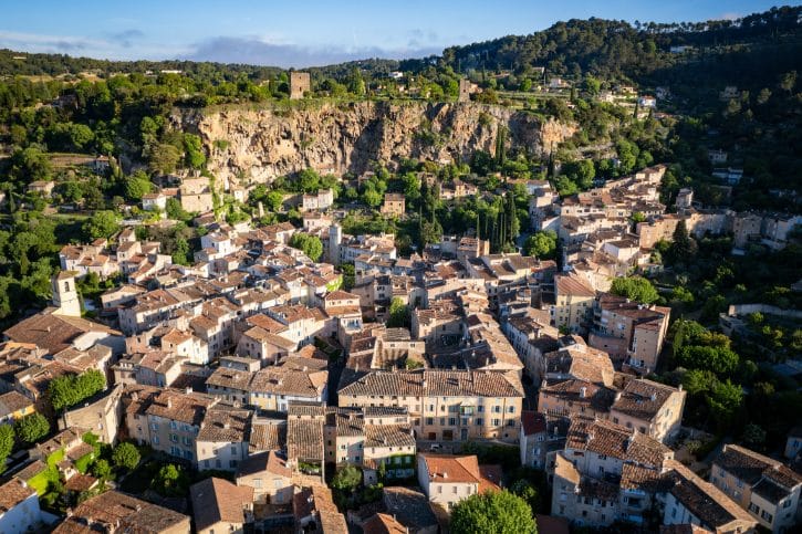
Cotignac sits in the Var, in Provence Verte, built right against one of the region’s most dramatic backdrops. It’s a member of Les Plus Beaux Villages de France, so it isn’t undiscovered, just unforgettable to look at.
The centerpiece is Le Rocher, an 80-meter-high, 400-meter-long tufa cliff towering over the rooftops, full of natural caves and overhangs.
b. What to see
- Cours Gambetta. The main street, shaded by century-old plane trees and lined with cafés, the best place to first take in the cliff.
- The village core. Lanes lead to the cliff base, where houses lean directly against the rock.
- The troglodyte dwellings. Climb into the caves carved into the cliff. Once refuges and later storerooms, they still show mangers cut into stone, chimney flues, and a stone dovecote.
c. A second, higher viewpoint
- Les Tours Sarrasines. Two 12th-century towers at the top of the cliff. Despite the “Saracen” name, local lords built them as watchtowers over the valley. The orientation table opens a wide view over Var olive groves and vineyards.
- Sanctuaire Notre-Dame-de-Grâces. On nearby Mont Bessillon, founded after reported apparitions in 1519, and site of a royal pilgrimage by Louis XIV in 1660.
d. Access and timing
A few conditions genuinely shape the visit:
- The upper cave path is closed during and just after rain for safety.
- Reaching the caves means steep, narrow steps with exposed drops, which can be hard for anyone with vertigo.
- Access can vary by season, so stay flexible.
Give yourself a half day, 3 to 4 hours or more. Between the village, the caves, the towers, and the sanctuary, plus a Tuesday market on Cours Gambetta, this is worth several hours, not a quick stop.
10. Callian, spiral lanes around a private hilltop castle in the Pays de Fayence
a. Why Callian is a pleasure
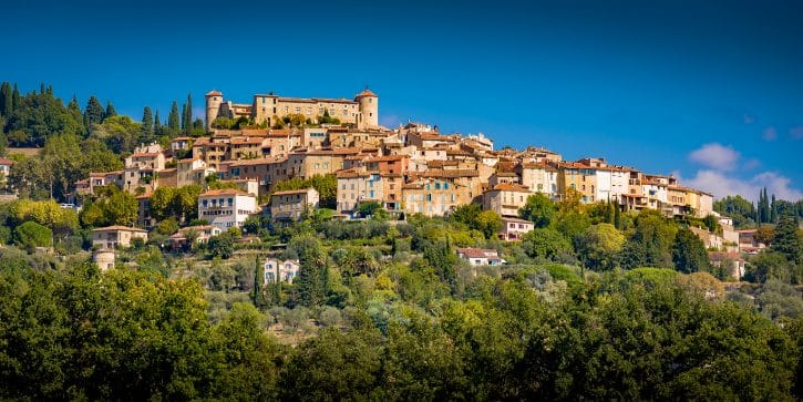
Callian sits in the Var, in the Pays de Fayence, on a limestone knoll at 325 meters. It has no single famous sight, and that’s fine, because the village itself is the attraction.
Its streets wind in concentric spirals around a hilltop castle, so the views keep shifting and opening as you climb. Quieter than nearby Fayence and Seillans, it’s all about the pleasure of exploring.
b. Following the spiral
- Place Honoré Bourguignon. A shady square at the base with a stone waterfall fountain and old plane trees.
- The spiral lanes. Concentric paths past stone archways, covered vaults, an old washhouse, and flower-lined alleys.
- Église Notre-Dame-de-l’Assomption. A 17th-century church with a bell tower of glazed Provençal tiles.
- The castle perimeter. The crown of the village.
One thing to know: the Château de Callian is a private residence and closed inside, except the guard room on heritage days. You still enjoy it from the perimeter terrace, which offers a fine panorama.
c. A little history
- The castle grew from a 12th-century fortress, restored in 1966 by Belgian artist Henri Brifaut.
- The valley holds the 10th-century Chapelle Notre-Dame-des-Roses, the oldest religious building here, built over a Gallo-Roman villa and cemetery.
- Callian drew creative names too: Christian Dior owned a nearby property, and the artists Fernand and Nadia Léger are buried locally.
d. How long to stay
- Explore the spiral center, the castle exterior, and the church.
- Add a walk to the Chapelle Notre-Dame-des-Roses or the nearby Lac de Saint-Cassien.
Plan a half day, around 3 to 4 hours. With a surrounding walk and time on the terrace, Callian gives you more than its size suggests.
11. Tourrettes-sur-Loup, a violet-growing fortified village on the Côte d’Azur hinterland
a. A quick word on geography
Tourrettes-sur-Loup sits in the Alpes-Maritimes, in the hinterland behind the Côte d’Azur, between Vence and Grasse. It appears in regional guides because it’s part of the Provence-Alpes-Côte d’Azur region, but it’s more accurate to call it a Côte d’Azur hinterland village than one of inland historic Provence.
b. What makes the old village distinctive
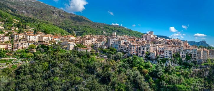
It’s a village rempart, built on a narrow limestone spur with steep drops into the Loup valley:
- Porte de l’Horloge. You enter through a medieval belfry tower.
- Grand-Rue. The main street curves in a crescent along the cliff, its outer houses forming a continuous defensive wall.
- Artisan workshops. Working studios line the street: woodworkers, weavers, potters, sculptors, and jewelers.
- Château-Mairie and Église Saint-Grégoire. A 15th-century castle, now the town hall, beside a 16th-century church with carved retables and a Roman altar stone reused as a font.
Where Saint-Paul-de-Vence nearby feels polished and busy, Tourrettes keeps a quieter, hands-on character.
c. The violets, its living heritage
This is real, working agriculture, not tourist branding:
- Since 1880, growers have specialized in the fragrant Viola odorata ‘Victoria’
- The flowers went to Grasse for perfume and to confectioners for crystallized sweets and syrups.
- La Bastide aux Violettes, just outside the center, is a museum and greenhouse where you can see the growing beds and learn how flowers are picked by hand from November to March.
- The Fête des Violettes marks the harvest’s end, usually late February or early March, with decorated streets and a flower parade.
d. How long to stay
- The violet season runs winter into early spring; outside it, the museum, crafts, and village still shine.
- Leave time to browse the artisan workshops, a big part of the pleasure here.
- Expect some steep, uneven walking on the spur.
Allow a half day, 3.5 to 4 hours or more, with the fortified center, the workshops, and La Bastide aux Violettes. Late afternoon in summer brings clear views toward the sea.