You don’t need long drives to see the best of Brittany. In one easy loop, you move from massive frontier castles to tidal oyster beds, wind carved granite coasts, and quiet inland villages full of art and Breton tradition.
Many stops sit just 30 minutes to an hour apart, so the road never wears you out. What ties it all together is a simple story of stone and sea. Fifteen stops, one journey, and a peninsula that surprises you at every turn. 😊
1. Fougères
a. Your gateway to the frontier
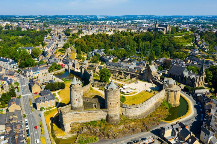
You start where Brittany once defended itself. Fougères sat on the Marches of Brittany, the contested border with the Kingdom of France. It grew as a shield, built to guard the invasion routes coming down from Normandy and Maine.
b. A castle built low, on purpose
Look closely and you’ll notice the castle sits in a valley, not on a hill:
- Builders placed it in a natural basin shaped by the looping Nançon River, on hard schist rock.
- They could dam the river and flood the ground, turning the land into moats and marshes.
- Siege engines and tunneling attacks simply drowned in the mud.
- You’re looking at two hectares of fortress, wrapped in three rings of walls.
c. Towers to spot
As you stand below the walls, compare the shapes across four centuries of warfare:
- Tour Mélusine: tall and slim, named after the fairy serpent the Lusignan family claimed as an ancestor.
- Tour Raoul and Tour Surienne: squat and massive, with walls up to 7 meters thick, built for cannon.
- Keyhole cannon openings: wide slots designed to sweep the riverbank with flanking fire.
- Tour Surienne’s name: it recalls a Spanish mercenary whose surprise night attack broke into the town in the 15th century.
d. Lower town and the best view
Below the castle spreads the lower town around the Church of Saint-Sulpice, a Flamboyant Gothic granite church with an off center slate spire. The Nançon once powered its mills.
To see it all, climb to the upper town and the terraces of the Jardin Public. From here the fortress, river loop, and both towns read as one connected defense. Trust me, this is the view that makes it click.
From this defended frontier, you head northwest toward the Channel, where tides and shellfish take over at Cancale.
2. Cancale
a. Tides that feed everything
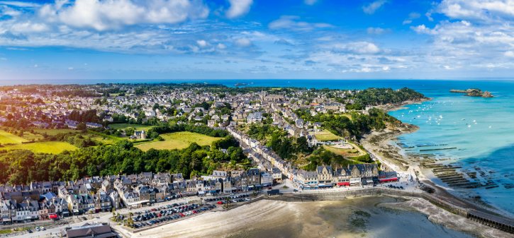
Cancale lives by the water. It sits in the western elbow of the Bay of Mont-Saint-Michel, one of Europe’s most extreme tidal areas, where the sea rises and falls by 12 to 14 meters on the big spring tides. Twice a day, that huge flush carries in the plankton that feeds the shellfish. That is the whole reason this coast became famous.
b. The two oysters
Cancale’s story runs through two very different oysters:
- The European flat oyster (belon): the native species, once wild across the seabed, harvested by sailing boats for centuries, then nearly wiped out by overfishing and parasites. Small amounts still grow offshore.
- The Pacific cupped oyster: the hardy newcomer that now makes up most of the harvest, grown on raised steel tables in mesh bags in the tidal zone.
c. The market beats the restaurant
At the Port de la Houle, seeing the producers gives you more than any menu:
- Cancale’s oyster culture is listed on France’s National Inventory of Intangible Cultural Heritage, honoring local knowledge, skill, and community bonds.
- At the Marché aux huîtres, small striped stalls are run by the growers themselves.
- You can buy oysters fresh, add lemon, and eat them on the sea wall looking at the very beds they came from.
d. Coastal viewpoints
Climb the cliff paths for the wider picture:
- Pointe des Crolles: right above the harbor.
- Pointe du Grouin: the rugged headland at the edge of the bay.
- From the point you see the bird island of Île des Landes and, on clear days, distant Mont-Saint-Michel.
From these working shores, you follow the coast west to Saint-Malo, where the sea meant trade, defense, and daring sailors.
3. Saint-Malo
a. The walled city
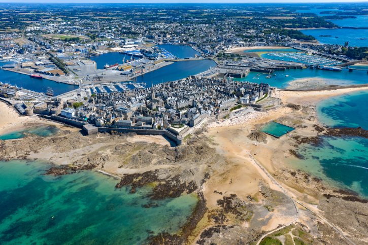
You arrive at a granite city pushing into the sea at the mouth of the Rance. Its heart is the walled town of Intra-Muros, ringed by a 1.75 kilometer loop of ramparts. Built on a rocky island, the walls were strengthened for centuries, with major upgrades shaped by the famous engineer Vauban.
b. Walking the ramparts
Walk the walls with purpose and look for:
- Bastion de la Hollande: a raised gun platform still fitted with bronze cannon.
- Porte Saint-Vincent and Grand’Porte: heavy gateways with portcullis channels and gun loops.
- Seaward views: beaches, tidal islands, and the harbor channels the walls once guarded.
c. Corsairs, not pirates
Get the terms right, because locals do:
- Corsairs: licensed shipowners carrying a royal Letter of Marque, bound by law, required to treat captured crews humanely.
- Pirates: outlaws with no commission, attacking any ship, facing execution if caught.
- Famous names like Duguay-Trouin and Surcouf worked inside the legal system, so they were raiders for the crown.
d. War, rebuild, and Grand Bé
The polished look hides a hard truth. In 1944, heavy shelling burned about 80 percent of Intra-Muros. Between 1948 and 1960, architect Louis Arretche rebuilt it in reclaimed granite, keeping the old street plan. So much of what looks ancient is a faithful reconstruction.
Just offshore lies the tidal island of Grand Bé, resting place of the writer Chateaubriand. Be careful here:
- A stone causeway from Bon Secours beach is safe only at low tide.
- Rising water covers the path with dangerous currents, so always check the tide times first.
From these coastal ramparts, you turn inland along the Rance to the medieval town of Dinan.
4. Dinan
a. A town built on a slope
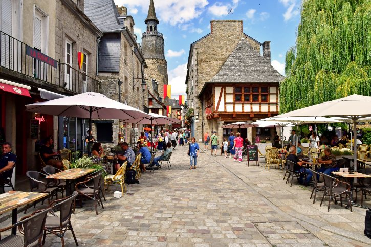
Dinan is all about height. You have a small river port at the bottom and a fortified medieval town on a granite plateau about 75 meters above. Down at the water, the port worked for centuries, passing wine, salt, leather, and grain from seagoing boats onto river barges.
b. The climb up Rue du Jerzual
Connecting the two is a steep, cobbled street climbing at a knee testing gradient. As you climb, look for:
- Granite storefront arches: ground floor shops where artisans once sold straight onto the street.
- Timber framing: upper floors of heavy oak, often jutting out over the lane.
- Carved corbels: beam ends showing saints, merchant symbols, and medieval faces.
- Guilds of tanners, weavers, dyers, and coopers once worked here.
c. The fortifications
At the top stands the fortified Porte du Jerzual, set into a 2.7 kilometer ring of walls that still keeps 10 towers and 4 gates:
- Tour Sainte-Catherine: built on a granite crag with sweeping valley views.
- Tour Coëtquen and the ducal keep: thick masonry with vaulted gun rooms.
- Tour Beaumanoir and Tour Lesquen: rounded artillery towers for flanking cannon fire.
d. Churches and reopened ramparts
The town was more than a fortress. The Basilica of Saint-Sauveur blends a Romanesque doorway with a Gothic nave and holds the heart of the leader Bertrand du Guesclin.
Good news if you visit now. After a major restoration, the northern ramparts have reopened, and a second historic wall walk nearby has too:
- The restored Front Nord walk lets you stroll the ramparts past towers like Saint-Julien, Lesquen, and Beaumanoir, entering from rue Michel or rue de l’École.
- Separately, the Porte du Jerzual wall walk, near the Tour du Gouverneur, is open again after years of closure.
- Between them, you get sweeping views over the old town and the Rance valley.
Leaving these defenses, you head to the Trégor coast, where wild granite starts to rule at Plougrescant.
5. Plougrescant and Castel Meur
a. Where land meets raw geology
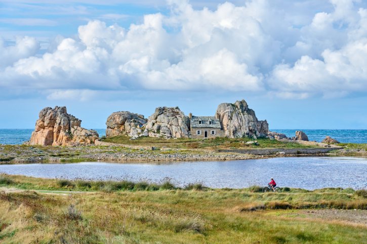
This stop is about human life meeting a fierce granite shoreline. The star feature is the Site du Gouffre, a deep, jagged chasm formed when the sea worked into the rock and collapsed an old cave. During big swells, waves funnel through the narrow slot and boom against the stone.
b. What to look for
Take your time along the coast and watch for:
- the fractured granite cliffs and the sea chasm itself
- offshore reefs and islands breaking the swells
- storm pebble beaches and sandbars shaped by the waves
- wide views from Pointe du Château over the archipelago
c. Castel Meur, and the rules
Wedged between two giant boulders sits the little stone cottage of Castel Meur, built to face away from the westerly gales. It makes an unforgettable photo, but please respect it:
- It is strictly private property, not a museum.
- The grounds are closed, so do not approach the house or cross any walls.
- View and photograph it only from the public coastal path.
d. A protected place
The whole area is carefully protected, and that shapes your visit. It sits within the European Natura 2000 network for fragile coastal habitats. The Maison du Littoral, in a restored cottage near the parking, explains the moorland, rare salt loving plants, and nesting seabirds. To protect the ground, stay on the marked gravel paths and never walk on the pebble storm ridges.
From these crevices, you travel west to the Pink Granite Coast, where color and sculpted rock take center stage.
6. Pink Granite Coast and Ploumanac’h
a. A sculpture park of stone
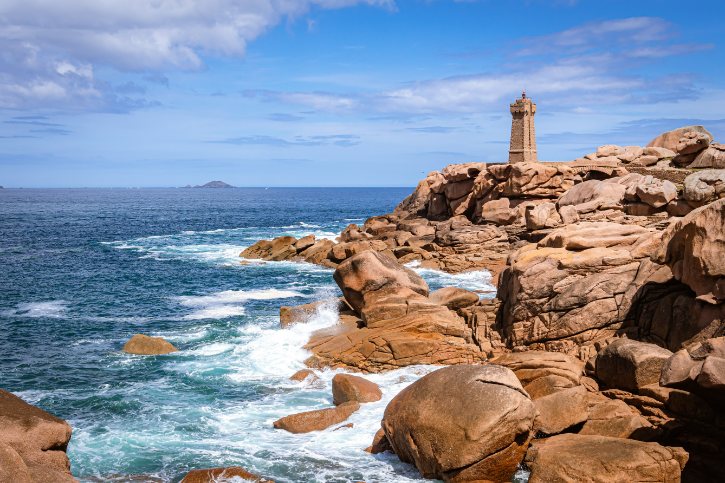
At Ploumanac’h, the granite itself is the reason to come. This is not really a beach resort. It is a landscape of rounded, rose colored boulders, stacked and smoothed on a giant scale.
b. Why the rock is pink
The story goes back hundreds of millions of years:
- The granite formed deep underground, cooling slowly and growing large crystals.
- The pink color comes mainly from potassium feldspar, mixed with gray quartz and black mica.
- Over vast time, water broke the rock along its cracks, and erosion left the rounded cores behind.
c. Walking the coast path
The best way to feel it is on foot, along the famous customs officers’ trail between Trestraou beach and the port. As you walk, look for:
- rounded masses, stacked formations, and lone balanced boulders
- narrow gaps and passages between the rocks
- sheltered coves and shifting colors as the light changes
- nicknamed rocks like Napoleon’s Hat and the Rabbit
d. Lighthouse, beach, and best light
At the center stands the Mean Ruz lighthouse, rebuilt in local pink granite after wartime damage, so it seems to grow from the bedrock. Below it lies sheltered Saint-Guirec beach, with its 12th century granite shrine on the sand.
For the richest color, time your visit well:
- Come in early morning or late afternoon.
- Low sunlight deepens the pink and sets it against blue water.
- Keep to the marked paths to protect the recovering heath.
From this warm toned coast, you continue west to Roscoff, where the shoreline turns to a human story.
7. Roscoff
a. A merchant town, not just a harbor
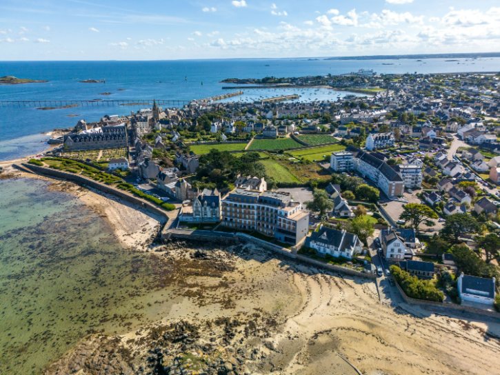
Roscoff looks pretty, but it earned its living as a serious trading town with strong links across the Channel. In the 16th and 17th centuries it grew rich exporting fine Breton linen, and that wealth built grand granite mansions across the old center.
b. Mansions to admire
Along the old streets, look up and notice:
- Watch turrets: small stone lookout posts on corners, used to spot arriving ships.
- Carved dormers: Renaissance windows with scrolls, pinnacles, and family crests.
- Granite cellars: vaults built for rolling in barrels and storing goods.
c. The Johnnies and the onion
Roscoff is famous for the Johnnies, farmers who sold onions door to door across Britain:
- The trade began in the 1820s, when a local farmer sailed his onions to England.
- Every year, young men crossed the Channel with bicycles and braided strings of onions.
- The Roscoff Onion now carries a Protected Designation of Origin, prized for its pink color and sweet taste.
d. A church and a garden
In the old town, the church of Notre-Dame-de-Croaz-Batz shows carvings of merchant ships on its walls, a nod to the shipowners who funded it. Look inside for its Flemish alabaster altarpieces.
At the edge of town, the Jardin Exotique et Botanique holds thousands of species from South Africa, Australia, and South America. It thrives because the warm Atlantic current keeps the winters almost frost free, letting tender plants grow outdoors all year.
From this outward looking harbor, you turn inland to Locronan, trading sea trade for sacred tradition.
8. Locronan
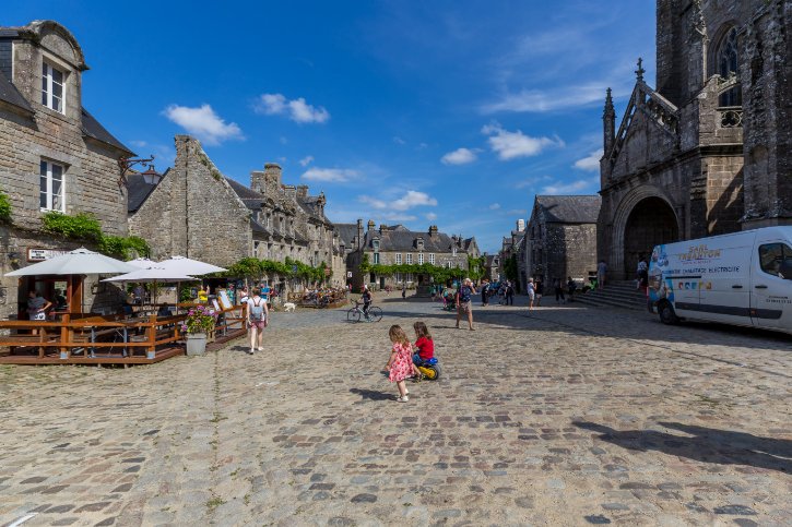
a. More than a pretty village
Locronan is more than lovely streets. Its real theme is the bond between its granite houses, an ancient pilgrimage, and the sacred countryside all around. Its beauty was paid for by industry, specifically the weaving of sailcloth that once supplied navies and merchant fleets.
b. Why it looks so perfect
The harmony survives for clear reasons:
- The buildings use bluish gray granite, with Renaissance windows and steep slate roofs.
- Power lines, cables, and plastic signs are kept out of the village core.
- The result is a 16th to 18th century streetscape you see almost untouched.
c. Église Saint-Ronan
The main square is dominated by the Church of Saint-Ronan, built under the Dukes of Brittany. It has Flamboyant Gothic vaulting, a large Passion window, and a carved pulpit telling the life of Saint Ronan, the Irish hermit who settled here. Beside it, a chapel holds his stone tomb, where six carved angels support the slab.
d. The Troménie
Locronan hosts one of Brittany’s oldest pilgrimages, and it runs in two cycles:
- Petite Troménie: a 6 kilometer route around the town, held most years on the second Sunday of July.
- Grande Troménie: a 12 kilometer route over the mountain, held only once every six years, with 12 prayer stations marked by granite crosses.
- The route lines up with an ancient Celtic sacred enclosure, so the village sits at the center of a wider sacred landscape.
- The next Grande Troménie is planned for July 2031.
From these sacred hills, you head to the very edge of Cap Sizun, where quiet piety gives way to the Atlantic at Pointe du Raz.
9. Pointe du Raz
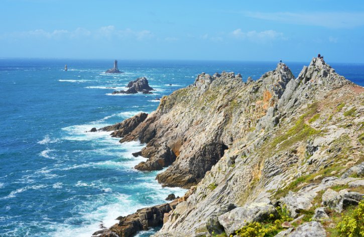
a. Brittany at its most raw
This is the most elemental stop on your trip. The granite cliffs rise about 72 meters straight out of the Atlantic, and the wind and waves never stop. It is a place that reminds you how small you are against the sea.
b. Dangerous, famous water
Just offshore lies the Raz de Sein, a strait sailors have feared for centuries:
- Fierce tidal currents clash with Atlantic gales.
- The result is chaotic standing waves that have wrecked ships since ancient times.
- The low island of Île de Sein sits about 8 kilometers out on the horizon.
c. A protected Grand Site
Pointe du Raz carries the official label of Grand Site de France, and its history explains why:
- In the mid 20th century, cars and shops at the cliff edge trampled the land bare.
- A major project later removed the buildings and moved parking a kilometer inland.
- Today you explore on crushed stone paths and boardwalks that protect the fragile heath.
d. The lighthouses and the statue
Look west and you see a classic sea landscape. The square granite Phare de la Vieille stands on an isolated wave washed rock, and the far off Phare d’Ar Men marks the edge of the reefs, so distant it is rarely seen with the naked eye. Near the path stands the marble statue of Our Lady of the Shipwrecked, comforting a drowning sailor. Please stay on the paths, since the thin turf tears and erodes easily.
Turning inland, you reach Quimper, where art, religion, and craft return to the story.
10. Quimper
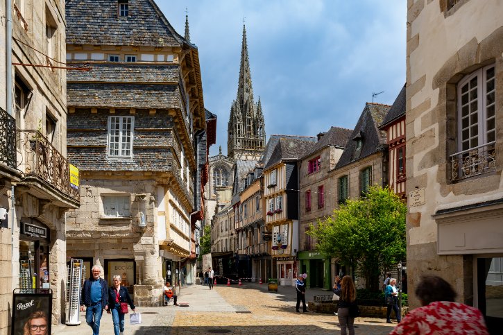
a. The cultural heart
As the old capital of Cornouaille, Quimper pulls together cathedral architecture, medieval streets, fine art, and famous pottery. Think of it as several identities in one city, not simply a pretty town.
b. Cathédrale Saint-Corentin
The center is dominated by one of Brittany’s largest Gothic cathedrals, and its most curious feature is a bend in the building:
- Stand at the west door and the choir clearly leans to the left.
- Legend says it echoes Christ’s head tilting on the cross.
- The real reason is that builders shifted the line to avoid unstable, swampy soil by the river.
- Look inside for the painted vaults bearing noble coats of arms.
c. Painted timber streets
Around the old center, the half timbered houses look different from Dinan’s granite fronts:
- exposed timber framing in crosses, studs, and diamond shapes
- facades painted in warm ochres, reds, blues, and yellows
- upper floors leaning out over the street to shelter the shopfronts
d. Pottery and painting
South along the river lies Locmaria, the birthplace of Quimper faience. Potters have worked here for more than three centuries, and the best known design shows figures in Breton dress framed by bold flowers.
Across from the cathedral, the Musée des Beaux-Arts holds a fine regional collection. It shows early works by the Pont-Aven School painters, so it makes a perfect warm up for your next art stop.
From this cultural capital, you return to the sea at Concarneau.
11. Concarneau and the Ville Close
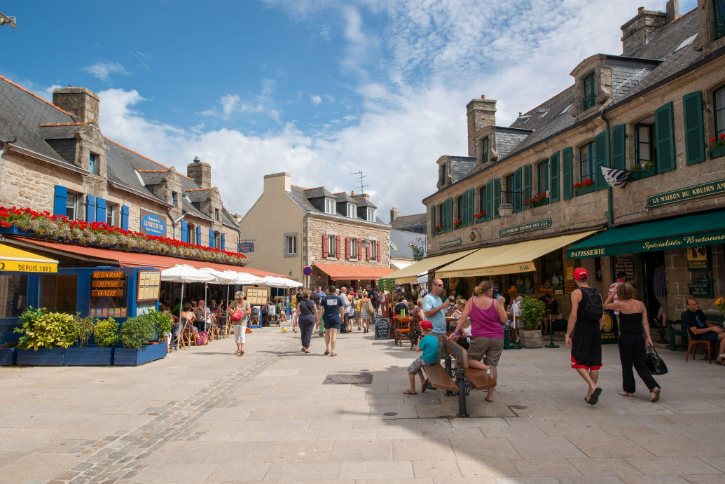
a. A fortress in a fishing port
Concarneau turns on one striking idea. A fortified medieval island, the Ville Close, sits right inside a working fishing harbor. That mix of old stone and live industry sets it apart from inland walled towns.
b. The island and its walls
You approach a long granite islet linked to the mainland by a stone bridge:
- The first walls went up under the Dukes of Brittany.
- The great engineer Vauban later modernized them for cannon, lowering the parapets and adding gun platforms.
- Look at how the gateway and its towers guard the narrow entrance before you step inside.
c. Life within the walls
Inside, the main street runs the length of the island, with small lanes opening onto a square with a granite fountain. Climb onto the ramparts for wide views back over the docks and repair basins. It is a rare chance to see medieval town life and a modern fishing port in one glance.
d. Fishing and the Blue Nets
Concarneau is still one of France’s leading fishing ports, and its history lives on in a famous festival:
- The Musée de la Pêche, in a former arsenal, lets you board a preserved trawler.
- The Fête des Filets Bleus began as a charity festival after a sardine crisis left families hungry.
- It grew into an August celebration of Breton culture, with folk groups and pipe bands.
From these working docks, you head into the Aven valley, where the countryside inspired a revolution in painting.
12. Pont-Aven
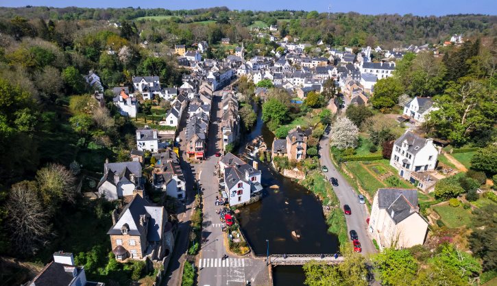
a. Where landscape became art
Pont-Aven is not simply the village where Gauguin lived. It is where the real countryside became the raw material for modern art. It sits in a wooded valley where the Aven tumbles over granite down to a tidal river.
b. From mills to painters
Before the artists came, this was a busy milling town:
- An old saying describes a place of fourteen mills and fifteen houses.
- The steep river powered a line of grain mills along both banks.
- You can still see the granite channels and wheels of surviving mills.
c. The Pont-Aven School
By the late 1880s, Paul Gauguin had arrived with Émile Bernard and Paul Sérusier, and together they broke from Impressionism:
- Color: bold, flat planes of pure color chosen for feeling.
- Line: strong dark outlines around those flat areas.
- Idea: a blend of what the eye sees, the memory holds, and the heart feels.
In the nearby Bois d’Amour, Gauguin gave Sérusier the lesson that produced a founding icon of the Nabis movement. You can walk the marked path and compare the real river with the abstract way the artists reimagined it.
d. Musée de Pont-Aven
The town’s cultural anchor is the Musée de Pont-Aven, which traces the whole art colony with works by Gauguin, Bernard, Sérusier, and their circle. The museum also hosts major national interest exhibitions that change through the year, so it is worth checking the current program before you visit.
From this artistic town, you cross into the Morbihan and reach the tidal port of Saint-Goustan.
13. Saint-Goustan
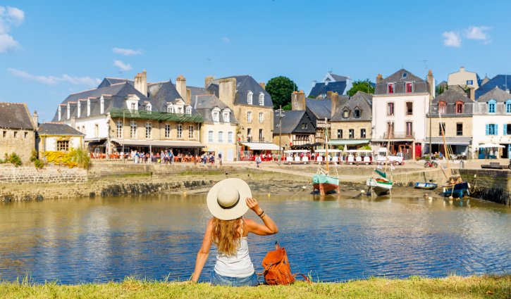
a. An intimate tidal port
Saint-Goustan is a small, historic port, the old harbor quarter of the town of Auray. Its character comes from its setting on a drowned river valley, where the tide reaches far inland.
b. Life on the tide
That tidal setting shaped everything:
- Twice a day, the sea pushes about 15 kilometers inland, deep enough for old sailing ships.
- Tucked well back from the Atlantic, the port stayed sheltered from storms.
- It served as the main harbor of the region from the Middle Ages into the 19th century.
c. From trade to marina
At its peak, ships unloaded iron, wine, and salt, then reloaded Breton timber, grain, and granite. Its decline came with progress, as the railway and larger steamships made the shallow river obsolete. So the port kept its old waterfront and became a gentle marina and artisan enclave, very different from Concarneau’s working docks.
d. What to see
Take your time around the harbor and its square:
- A four arched stone bridge has crossed the river since medieval times.
- Timber framed and granite merchant houses line the quay, with steep slate roofs.
- Quai Franklin recalls Benjamin Franklin, who landed here on a diplomatic mission.
- Climb to the plateau above for the best view over the horseshoe harbor as the tide fills it.
From this quiet port, you continue to Vannes, where the maritime landscape opens into a larger historic city.
14. Vannes
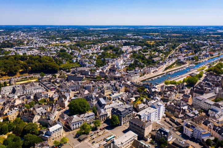
a. From marina to medieval streets
Vannes brings together a walled Breton city and a harbor linked to the Gulf of Morbihan. What makes it special is how quickly you step from the marina into gates, ramparts, timbered streets, and a great cathedral.
b. Ramparts and gardens
The city keeps a long circuit of walls, and the setting is lovely:
- Pass under the classical Porte Saint-Vincent to move from docks into medieval streets.
- The Tour du Connétable is a five story artillery tower with gun openings and fireplaces.
- The old moat below the eastern walls is now a formal French garden.
- Timber framed washhouses sit along the river at the foot of the ramparts.
c. Timbered streets and a carved couple
Inside the walls, the old town keeps more than 170 timber framed houses. Look for bright painted framing, leaning upper floors, and carved corner posts. At one street corner, find “Vannes et sa femme”, a carving of a smiling couple that was most likely once a merchant’s trade sign.
d. The cathedral and its history
At the top of the old town rises the Cathedral of Saint-Pierre, blending Romanesque foundations, a Gothic nave, and a Renaissance chapel. It holds the tomb of a Spanish preacher who died in the city. Vannes played a central role in Breton history, as a favorite seat of the Dukes and the place where the union of Brittany with France was ratified.
Leaving these ducal streets, the final leg turns into the Morbihan hills, ending at Rochefort-en-Terre.
15. Rochefort-en-Terre
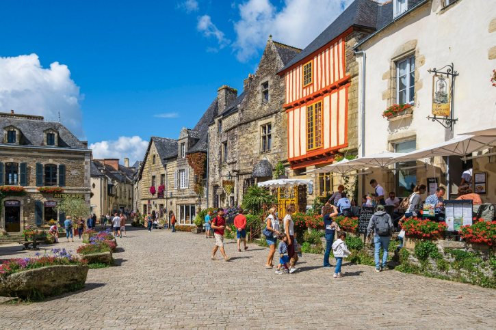
a. A carefully protected finale
Rochefort-en-Terre is the perfect closing note. The village looks unusually harmonious, and that look is no accident. Artists, local craft, and careful stewardship all shaped what you see today.
b. A different stone
Unlike the granite coast, this village is built from a different geology, and the mix is beautiful:
- Schist masonry: dark, layered blue gray stone giving a rich, rustic texture.
- Granite dressings: cut granite around windows and doorways for strength.
- Slate and timber: steep roofs, carved dormers, and wrought iron trade signs.
c. Streets and church
The heart of the village is Place du Puits. Take your time comparing the facades, looking for carved coats of arms and old storefront openings. The village was an early leader in the flowering villages movement, so ivy and window boxes are woven into the stone. Below, the church of Notre-Dame-de-la-Tronchaye is built into the hillside with an unusual stepped roofline and a carved granite calvary in its forecourt.
d. The château and Alfred Klots
The village’s modern revival is tied to the American painter Alfred Klots:
- He bought the ruined castle in the early 20th century.
- Rather than fake a rebuild, he made a manor from genuine salvaged fragments.
- He founded an artists’ colony and started flower competitions that saved the village’s look.
Today the grounds are open with fine views, and the interiors house a private museum of fantasy art.